A mining program usually reaches the same pressure point sooner than expected: the geology team needs more coverage, the operations team cannot tolerate disruption, and management needs defensible data before committing more capital. That is exactly when should mines use drone geophysics becomes a practical decision, not a technology discussion. The question is less whether drone geophysics works and more whether it is the right acquisition method for the decision in front of the mine.
When should mines use drone geophysics in practice?
Mines should use drone geophysics when the value of faster, higher-resolution, lower-risk data outweighs the limits of ground crews or manned aircraft. In most cases, that happens in four situations: early targeting over difficult terrain, brownfield exploration near active infrastructure, rapid decision support for pit or plant expansion, and repeat monitoring where schedule discipline matters.
This is not a blanket replacement for every conventional survey. Fixed-wing aircraft still make sense for very large regional programs, and ground geophysics still has a role where ultra-dense line spacing or direct ground coupling is required. Drone platforms become compelling in the middle zone - where the area is operationally meaningful, access is constrained, and the project cannot afford slow mobilization or weak spatial control.
The strongest use case: time-sensitive targeting
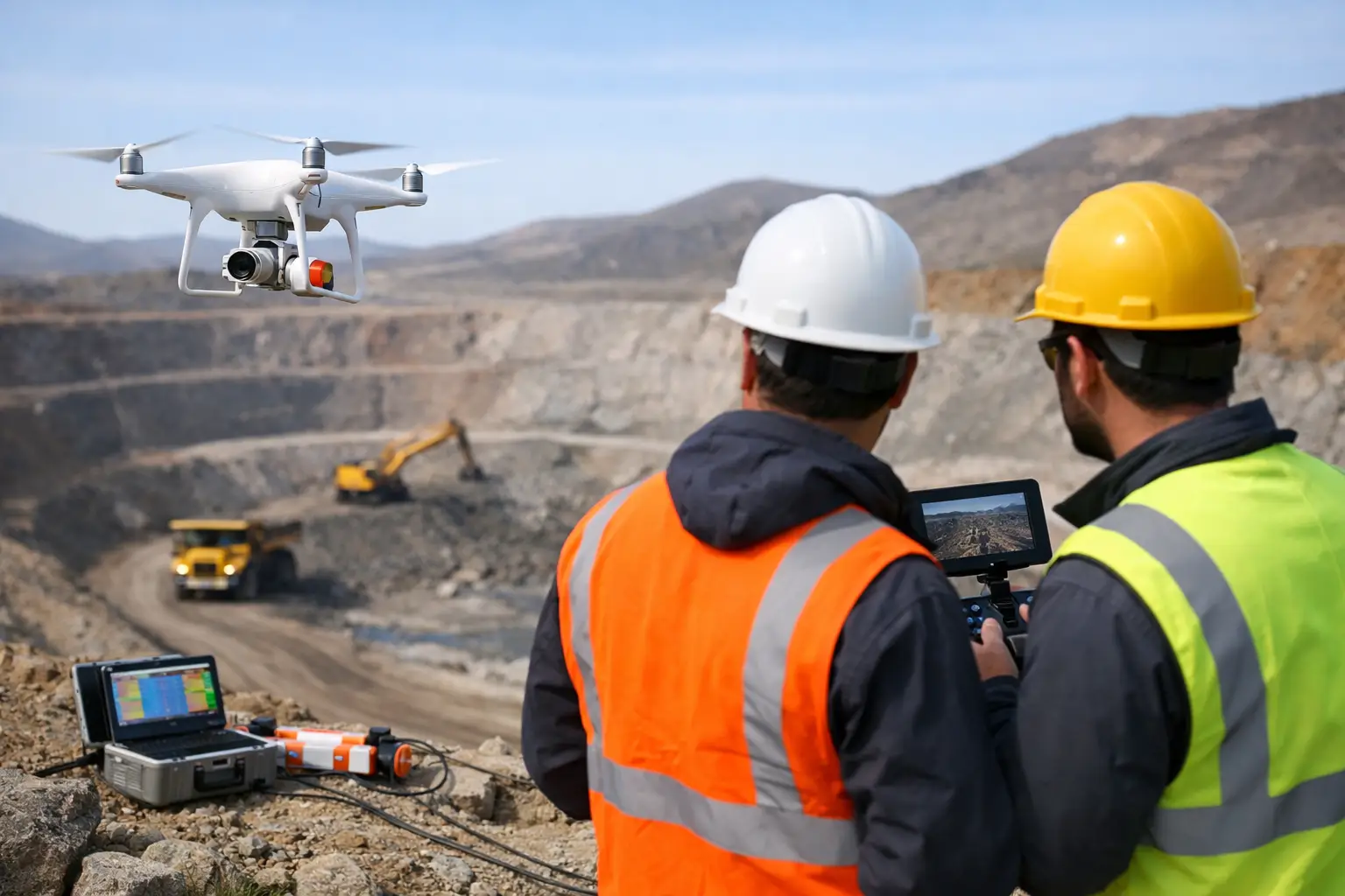
The clearest trigger is when a mine needs geophysical intelligence fast enough to influence the next field season, drill plan, or investment gate. Traditional survey methods often lose time in mobilization, permitting coordination, terrain access, and safety planning. Drone geophysics compresses that cycle.
For exploration managers, this matters when target ranking is still fluid. A calibrated aeromagnetic or electromagnetic survey can refine structural interpretation, identify alteration trends, and reduce the amount of unproductive drilling. In brownfield settings, where every drill meter competes with production priorities, reducing uncertainty before collar locations are finalized has direct commercial value.
Speed alone is not the argument. The real advantage is schedule certainty. A rapidly mobilized drone survey with documented QA/QC, repeatable flight parameters, and auditable processing creates usable geoscience products on a timeline that aligns with budgeting and drilling decisions.
Where terrain and access make ground surveys inefficient
Mines should also use drone geophysics when the survey area is physically accessible in theory but inefficient or hazardous in practice. Steep pit walls, waste dumps, fractured ground, remnant infrastructure, desert heat, and broad undeveloped lease areas all increase the cost and risk of ground-based acquisition.
This is especially relevant in arid mining environments, where long traverses expose crews to heat stress and vehicle logistics become a survey constraint. Drone platforms reduce ground exposure while maintaining controlled line geometry and sensor elevation. That produces cleaner, more spatially consistent coverage over areas where ground methods may degrade in both productivity and data continuity.
The same principle applies to zones around tailings, haul corridors, powerlines, and plant boundaries. If the objective is to map subsurface continuity without interrupting operations or placing crews in marginal environments, airborne low-altitude acquisition often becomes the more disciplined option.
Brownfield mines benefit earlier than many expect
A common mistake is to treat drone geophysics as an exploration-stage tool only. In reality, some of the best applications sit inside producing assets. Brownfield mines often have fragmented legacy datasets, uneven survey standards, and unresolved structural questions near known mineralization. Those conditions are ideal for targeted drone-based magnetic, electromagnetic, radiometric, or multisensor programs.
When should mines use drone geophysics at brownfield sites? Usually when existing information is good enough to define the problem but not good enough to de-risk the next capital step. That might mean extending ore controls beneath cover, tracing fault offsets across disturbed ground, or evaluating near-mine satellite targets that were previously ignored because access was poor or legacy airborne data was too coarse.
Drone geophysics is also effective when a site needs to re-survey selectively rather than commission a large conventional campaign. Focused acquisition over priority corridors allows the mine to improve local geological resolution without paying for unnecessary regional coverage.
Resolution matters when the target is subtle
Not every mining target needs the same sensor strategy. If the deposit model depends on subtle magnetic contrasts, conductive structures, regolith architecture, or narrow alteration trends, line spacing and terrain clearance become critical. This is where low-altitude drone acquisition often produces a material improvement in interpretability.
That does not mean drone geophysics automatically delivers better geology. Survey design still controls the outcome. A poorly specified program will remain poor regardless of platform. But when the target requires tight line spacing, stable terrain following, and consistent acquisition over irregular topography, drones can generate data density that would be expensive or impractical with manned aircraft.
For technical procurement teams, the implication is straightforward: the decision should be tied to the resolution needed to support interpretation, not to a generic preference for airborne methods.
Operational settings where disruption must stay low
Active mines cannot always tolerate survey logistics that interfere with production. Ground crews may conflict with haul traffic, blasting schedules, security controls, or restricted areas around critical infrastructure. Manned aircraft can also introduce operational coordination burdens, particularly where low-level flying needs to be tightly managed.
Drone geophysics becomes attractive when the survey must fit around the mine rather than the other way around. Smaller operational footprints, faster deployment windows, and targeted block coverage reduce interference. That matters for expansion studies, sterilization assessments ahead of infrastructure placement, and environmental or hydrogeologic investigations linked to mine planning.
In these cases, the best outcome is not simply more data. It is auditable data acquired without creating operational friction.
Cases where drone geophysics may not be the right choice
There are trade-offs, and sophisticated buyers should expect them. Very large regional tenement coverage may still favor manned aircraft on cost per square mile. Some methods remain more effective on the ground if sensor coupling or specific physical measurements are required. Airspace restrictions, topographic complexity, and local regulatory conditions can also affect feasibility.
Battery endurance, payload limits, and production rates matter as well. A drone program that is ideal for a 20 to 80 square mile priority block may be inefficient for a much larger basin-scale reconnaissance campaign unless the scope is staged carefully. The right question is not whether drone geophysics is better in general. It is whether it is superior for this area, this target, and this decision timeline.
That is why serious programs begin with a survey design review, not a platform preference. Sensor selection, line orientation, nominal spacing, terrain clearance, calibration, base-station strategy, and processing workflow all need to align with the geological question being asked.
What decision-makers should look for from a contractor
If a mine is considering drone geophysics, the procurement decision should focus on technical execution, not only aircraft capability. The contractor needs to demonstrate calibrated acquisition, documented QA/QC, positional traceability, and interpretation workflows that convert sensor outputs into decision-grade geoscience products.
That is particularly important in mining jurisdictions and enterprise settings where datasets must stand up to internal technical review, investment committee scrutiny, and future integration with drilling, mapping, and resource models. Raw data volume is not the deliverable. Interpreted, cross-validated intelligence is.
For mines operating in harsh environments, execution maturity matters even more. Desert-ready mobilization, thermal operating discipline, repeatable field procedures, and clear reporting standards are not marketing extras. They determine whether the final dataset can actually support planning. This is where a specialist provider such as Air Solutions can differentiate - not by offering another drone, but by delivering a fully auditable geoscience workflow built for industrial use.
A practical trigger point for mine operators
If a mine is delaying a drilling decision because coverage is incomplete, if crews are struggling to survey safely or consistently on the ground, or if legacy airborne data is too coarse to resolve the next target, the trigger point has probably already arrived. Drone geophysics is most valuable when uncertainty is expensive and the mine needs better subsurface intelligence without absorbing the delay, risk, or disruption of heavier survey methods.
The best time to use it is not after options have narrowed. It is when one well-designed survey can still change the quality of the next decision.