A single sensor rarely answers the question that matters on a mine site, utility corridor, or water exploration program. The real shift behind the emerging trends in multisensor surveying is not more data for its own sake. It is the move toward calibrated, cross-validated intelligence that shortens decisions, reduces field exposure, and stands up to technical scrutiny.
For enterprise buyers, this change is operational rather than cosmetic. Survey programs are being evaluated on mobilization speed, traceable QA/QC, interpretive value, and how well outputs support engineering, permitting, exploration targeting, and asset risk management. In that environment, multisensor workflows are no longer a specialist add-on. They are becoming the default architecture for projects where uncertainty is expensive.
Why emerging trends in multisensor surveying matter now
The pressure is coming from both sides. On one side, infrastructure, mining, water, and energy projects need denser and more reliable geospatial intelligence under tighter timelines. On the other, field conditions remain difficult, especially across remote, high-temperature, or access-constrained environments where conventional manned acquisition or ground methods create cost and safety penalties.
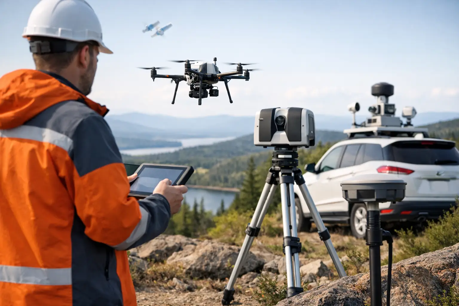
Multisensor surveying addresses that gap by combining complementary sensing modalities into a single decision framework. LiDAR resolves terrain and structure with high geometric fidelity. Photogrammetry adds visual context and orthomosaic detail. Magnetics, electromagnetics, radiometrics, and hyperspectral data contribute subsurface, material, and alteration indicators that surface mapping alone cannot provide. The trend is toward integrating these layers earlier in the workflow, rather than treating interpretation as a downstream exercise.
That matters because data fusion changes the quality of the decision. A topographic anomaly is one thing. A topographic anomaly that aligns with magnetic structure, conductivity contrast, and spectral alteration signatures is a different class of target entirely.
Trend 1: Sensor fusion is moving from parallel capture to integrated interpretation
Historically, many survey programs collected multiple datasets but processed them in relative isolation. The deliverable was often a stack of maps, each technically valid, but only loosely connected. That model is weakening.
The stronger trend is fully integrated interpretation, where spatial co-registration, timing synchronization, calibration records, and cross-sensor validation are planned from the start. This shifts value away from raw acquisition volume and toward interpretable outputs. For technical procurement teams, that distinction is significant. Buying multiple datasets is not the same as buying one coherent geospatial intelligence product.
The trade-off is complexity. Integrated interpretation requires tighter flight planning, stronger metadata discipline, and more rigorous QA/QC. If calibration drift, positional mismatch, or inconsistent resolutions are ignored, fusion can create false confidence instead of clarity. Mature providers are investing heavily in process control because fusion only works when the data stack is auditable.
Trend 2: Drone platforms are taking on more of the survey envelope
A major driver in emerging trends in multisensor surveying is the practical expansion of drone-based acquisition into tasks once reserved for crewed aircraft or ground teams. This is especially relevant for localized high-value targets, linear infrastructure, inaccessible terrain, and early-stage programs that need fast technical answers before scaling.
The advantage is not merely lower flight cost. It is the combination of rapid mobilization, lower logistics burden, safer access, and tighter survey repeatability. For corridor mapping, stockpile monitoring, tailings observation, utility detection support, and targeted geophysical campaigns, drones can now deliver resolution and operational flexibility that align well with project realities.
Still, it depends on scale and purpose. Wide-area regional campaigns may still justify crewed platforms in some cases, particularly where payload, endurance, and coverage economics dominate. The market is not moving toward a single platform replacing all others. It is moving toward fit-for-purpose architectures, with drones taking a larger share of missions where speed, precision, and deployment flexibility matter most.
Trend 3: QA/QC is becoming a buying criterion, not a technical footnote
As multisensor programs become more central to investment and engineering decisions, clients are paying closer attention to how data quality is documented. That means calibration logs, flight line checks, control network integrity, environmental condition records, processing lineage, and interpretation assumptions are becoming commercially relevant.
This is a notable market shift. In high-value sectors, buyers are increasingly less interested in attractive visualizations that cannot be traced back to defensible workflows. They want outputs that are fully auditable and suitable for board-level approvals, technical committee review, or regulator-facing documentation.
This trend favors providers with disciplined operating procedures. Air Solutions, for example, is positioned around documented QA/QC, proprietary fusion workflows, and sector-specific reporting. That alignment matters because enterprise clients are not purchasing imagery alone. They are purchasing confidence in the chain of evidence behind the interpretation.
Trend 4: AI is entering preprocessing and anomaly screening, but not replacing domain expertise
Artificial intelligence is now influencing multisensor surveying, mainly in preprocessing, classification, pattern detection, and anomaly ranking. Point cloud classification, image segmentation, change detection, and first-pass target extraction can now be accelerated significantly when machine learning models are trained on the right site conditions and asset types.
The opportunity is clear. Large datasets can be screened faster, routine interpretation tasks can be standardized, and analysts can spend more time on higher-order geological, hydrological, or infrastructure assessment. For repeat inspections and asset monitoring, this can improve consistency across survey cycles.
But there is a limit. AI models are only as good as their training data, and multisensor datasets are highly sensitive to environmental noise, sensor configuration, terrain effects, and project context. In mineral exploration, groundwater assessment, or utility risk mapping, false positives and false negatives carry real cost. The trend is not autonomous interpretation. It is supervised acceleration, where automated methods support specialists rather than displace them.
Trend 5: Time-series surveying is becoming standard for asset and environmental monitoring
Multisensor surveying is shifting from one-time acquisition toward repeatable monitoring programs. This is particularly visible in infrastructure deformation analysis, tailings storage monitoring, utility corridor encroachment, groundwater-related terrain response, and construction progress verification.
The reason is straightforward. Single surveys provide a snapshot. Repeated, cross-calibrated surveys provide behavior. Once clients can compare LiDAR surface change, thermal or spectral variation, and geophysical signatures over time, they gain an earlier view of movement, moisture shifts, instability, or asset degradation.
This has implications for procurement and project design. Monitoring programs require consistency in sensor configuration, control, processing standards, and reporting thresholds. If repeat surveys are not normalized properly, apparent change may reflect methodology drift rather than site change. The best operators design for temporal comparability from day one.
Trend 6: Sector-specific outputs are replacing generic map packages
Another important trend is the decline of generic survey deliverables. Enterprise buyers increasingly expect outputs tailored to the operational question. A hydrologist wants interpreted groundwater indicators and structural controls, not only elevation products. An exploration manager wants ranked targets with geophysical context and geological rationale. An infrastructure owner wants condition flags, clearance analysis, and asset-specific risk mapping.
This changes what good surveying looks like. Technical value now sits as much in interpretation design and reporting structure as in sensor performance. Multisensor datasets create the raw basis for analysis, but the commercial value is realized when outputs are organized around a use case, a decision gate, or a compliance requirement.
For providers, this raises the bar. It is no longer enough to be sensor-capable. They must also be sector-fluent.
Trend 7: Desert and harsh-environment optimization is becoming a differentiator
In the Gulf and similar operating environments, harsh-weather performance is not a niche consideration. Heat, dust, glare, remote access, and logistics constraints can materially affect survey quality and execution risk. One of the more practical emerging trends in multisensor surveying is the adaptation of workflows, payload integration, and mission planning for these conditions.
This includes thermal management, dust-tolerant field procedures, tighter calibration discipline under temperature variation, and platform selection based on payload stability rather than nominal specifications alone. It also includes planning around light angle, reflectance behavior, and seasonal environmental factors that affect spectral or photogrammetric results.
Clients should pay attention here because harsh-environment competence directly affects data reliability. A technically advanced sensor suite can still underperform if field execution is not engineered for local conditions.
What buyers should ask before commissioning a multisensor survey
The most relevant question is not which sensor is best. It is which sensor combination, workflow, and reporting structure best reduce uncertainty for the decision at hand. That requires clarity on the target, required resolution, site constraints, audit requirements, and how outputs will be used downstream.
A disciplined procurement process should test whether the provider can explain calibration methods, fusion logic, positional control, uncertainty limits, repeatability, and interpretation methodology in concrete terms. If those answers remain vague, the risk usually appears later in the form of ambiguous targets, rework, or low-confidence conclusions.
Multisensor surveying is moving toward a more mature model - faster to deploy, more integrated, more traceable, and more useful to decision-makers outside the survey team. That is the real direction of travel. The winners will be operators and clients who treat data acquisition not as a standalone service, but as part of a controlled intelligence pipeline built for action.