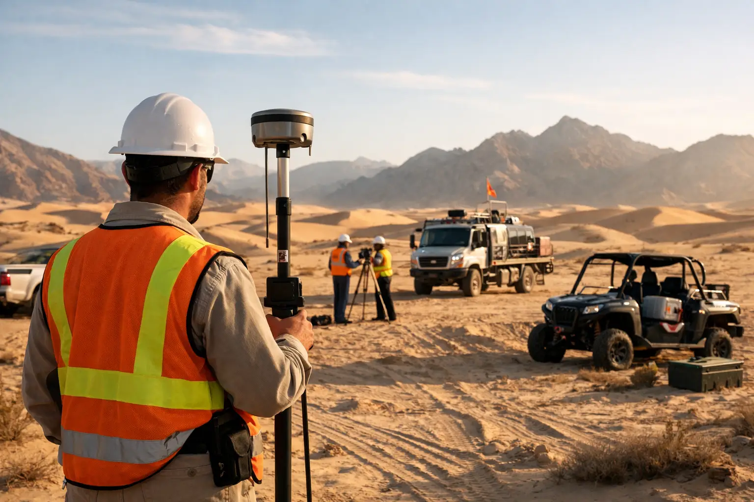
At 46 C with shifting sand across access tracks, mobilization is rarely a scheduling detail. It is the first technical test of the project. This desert survey mobilization case study examines how a drone-led geophysical and mapping campaign can be deployed quickly, controlled tightly, and documented to a standard that supports engineering, exploration, and government decision-making in harsh operating conditions.
For institutional buyers, the issue is not simply whether a survey can fly. The issue is whether the operation can establish field control, maintain calibration, protect data integrity, and deliver interpreted outputs without the delays and risk profile associated with conventional mobilization. In desert environments, every weak point becomes visible early - logistics, thermal management, crew endurance, GNSS reliability, dust ingress, and the discipline of field QA/QC.
What this desert survey mobilization case study is really testing
The case is representative of a large-area baseline intelligence requirement in an arid project corridor. The client needed terrain and subsurface insight to support downstream planning, with schedule pressure driven by parallel engineering and permitting workstreams. The scope combined high-resolution topographic capture with geophysical acquisition across a remote area where fixed infrastructure was limited and ground access was inconsistent.
A conventional manned-aircraft program would have introduced longer lead times, higher operating cost, and less flexibility for repeated low-altitude passes over priority zones. A ground-heavy approach would have reduced production rate and increased exposure to heat, access restrictions, and line-by-line variability. The selected operating model therefore centered on drone deployment with a calibrated sensor package, modular field logistics, and a processing chain designed for fully auditable deliverables.
The mobilization objective was straightforward on paper: move from authorization to field-ready operations in days, not weeks. In practice, that required a tightly controlled sequence. Permitting status had to be validated, survey geometry finalized, crew and equipment staged, battery and charging strategy matched to thermal conditions, and field verification procedures locked before departure. In the desert, loose planning tends to become lost production.
Pre-mobilization planning decides field performance
The most important decisions happened before the first vehicle moved. Area reconnaissance, access modeling, and weather pattern review shaped the deployment architecture. That included launch and recovery point selection, daily sortie planning, contingency routes, and communications coverage. In a benign environment, some of those decisions can be corrected in the field. In a remote desert block, late corrections usually cost a full operating day.
Sensor selection also required discipline. Not every project benefits from loading every available modality. Payload mass, flight duration, line spacing, altitude, and required resolution are interdependent. If the objective is to generate decision-grade geoscience rather than a collection of loosely related datasets, the mission plan has to prioritize the sensing stack that best supports the client decision. In this case, the acquisition architecture was built around high-value data density and repeatable coverage, not novelty.
The field package was then organized as a controlled system rather than a collection of tools. Aircraft, sensors, GNSS equipment, batteries, chargers, spare parts, calibration fixtures, and storage media were logged into a mobilization register. Crew roles were fixed in advance. Daily checklists, fault reporting, and chain-of-custody procedures were established before deployment. That level of preparation matters because desert work punishes improvisation.
Mobilizing into heat, dust, and distance
On arrival, the first operational priority was not flight volume. It was control establishment. Ground control and positional verification had to be confirmed, environmental conditions documented, and equipment health checked after transit. A rushed first day often creates invisible error that only appears during processing.
Heat management shaped the daily operating cycle. Batteries were stored and rotated under thermal controls. Aircraft and sensors were protected from direct heat loading between sorties. Crew schedules were built around safe high-output work periods rather than nominal daylight availability. Dust mitigation was equally critical. Landing protocols, cleaning intervals, and enclosure management reduced contamination risk to optics, motors, connectors, and storage interfaces.
Mobility across the survey area was handled through a leapfrog deployment model. Rather than overextending from a single base, the team repositioned through predefined field nodes that balanced access, airspace practicality, and production efficiency. That reduced deadhead time and preserved battery cycles for productive acquisition. It also improved resilience. If one node became temporarily unusable because of terrain, visibility, or access constraints, the operating plan could shift without compromising the broader grid.
The practical value of drone-based mobilization became clear here. The field unit could adapt line priorities, revisit anomalous zones, and densify local coverage where early observations justified it. With conventional aviation, those changes often require costly rescheduling. With disciplined UAV operations, they can be absorbed into the active campaign without losing control of QA/QC.
QA/QC is where a case study becomes decision-grade
A credible desert survey mobilization case study is not a story about endurance alone. It is a story about control. Data quality in harsh conditions depends on whether calibration checks, positional validation, line tie assessment, and metadata capture are treated as operational essentials rather than administrative tasks.
In this case, field QA/QC was embedded into the production rhythm. Pre-flight checks confirmed aircraft status, sensor readiness, GNSS integrity, and mission configuration. Post-flight checks reviewed completeness, file integrity, environmental observations, and operational anomalies. Test lines and repeat segments were used to verify consistency. Daily data backups followed a documented hierarchy with duplication across secure media.
That process delivered two commercial advantages. First, it reduced the probability of discovering quality defects after demobilization, when recovery is expensive or impossible. Second, it gave the client a traceable basis for confidence. For enterprise and government buyers, confidence is not created by a promise of accuracy. It is created by documented evidence showing how accuracy was achieved, verified, and preserved through the workflow.
Cross-validation during processing was equally important. Positional corrections, line leveling, sensor-specific noise filtering, and terrain reconciliation were not handled as isolated technical steps. They were treated as linked controls in a unified processing environment. When datasets from different modalities are intended to inform planning or exploration targeting, consistency between them matters almost as much as standalone quality within each stream.
Where schedule gains actually came from
The schedule improvement in this case did not come from flying faster in a simple sense. It came from compressing non-productive time. A drone-led deployment reduced dependence on major airfield logistics, shortened staging cycles, and allowed the field team to operate closer to the survey block. It also reduced the waiting periods that typically accumulate around aircraft availability, crew repositioning, and partial remobilization.
There is, however, a trade-off. Drone operations require more granular mission planning and more active battery, payload, and line-management discipline than many buyers expect. They are not a shortcut for poor field management. In fact, the operational tempo can be higher because the system is more flexible. That flexibility only creates value when mission control, data handling, and field maintenance are executed with rigor.
For clients in mining, water resources, utilities, and corridor infrastructure, this is usually the central calculation. The question is not whether drones are newer. The question is whether they can produce defensible data with a better risk and time profile for the specific terrain, target depth, required resolution, and reporting standard. In broad desert environments, the answer is often yes, but not universally. Very large regional extents, extreme endurance requirements, or highly specialized payload constraints can still favor other platforms. Good survey design starts with that reality.
Operational lessons for future deployments
Several lessons emerged from the project. First, mobilization speed is only useful when paired with calibration discipline. Rapid deployment without verified control simply moves uncertainty earlier in the schedule. Second, desert readiness is a systems issue, not a vehicle feature. Aircraft capability matters, but so do thermal handling, dust controls, crew procedures, and field data governance. Third, interpreted output should shape acquisition design from the start. If the final deliverable is intended for exploration targeting, groundwater assessment, or engineering planning, the field campaign should be configured around that end use rather than around sensor availability.
This is where a specialist operator has a measurable advantage. A company such as Air Solutions is not selling flight hours in isolation. It is structuring a mission so that mobilization, acquisition, QA/QC, processing, and interpretation function as one controlled chain. That distinction matters to procurement teams because the commercial risk usually sits at the interfaces between those stages.
For project owners working across Saudi Arabia and the wider Gulf, the broader implication is clear. Desert conditions do not need to force long mobilization cycles or compromise data quality. What they do require is an operating model built for heat, distance, access variability, and auditable technical execution. When that model is in place, a survey campaign becomes more than a field exercise. It becomes a faster route to defensible decisions, which is usually the metric that matters most when capital, schedule, and public accountability are all on the line.
The useful question for the next project is not whether mobilization can be accelerated. It is whether acceleration can occur without weakening traceability, calibration control, or the value of the final interpretation.