When a project team is making decisions on drill targeting, groundwater potential, corridor routing, or buried infrastructure risk, surface observations are rarely enough. Airborne geophysical mapping gives decision-makers a faster way to characterize large areas, detect subsurface contrasts, and reduce uncertainty before capital is committed. For operators working across Saudi Arabia and the Gulf, that speed matters, but so does data quality, auditability, and the ability to perform in heat, dust, and remote terrain.
What airborne geophysical mapping actually does
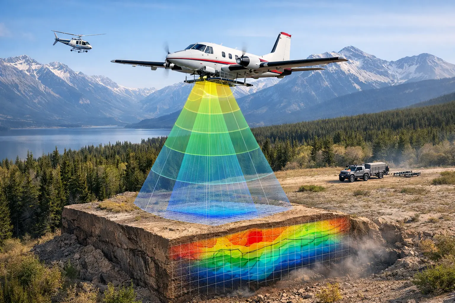
At its core, airborne geophysical mapping measures physical property variations from the air and converts them into interpretable spatial intelligence. Depending on the sensor package, that can include magnetic susceptibility, electrical conductivity, radiometric response, elevation, surface geometry, or spectral characteristics. The objective is not simply to collect airborne readings. It is to produce calibrated, cross-validated datasets that support engineering, exploration, environmental, and planning decisions.
This distinction matters. Raw geophysical signals have limited value without positioning control, line calibration, noise suppression, diurnal correction where required, terrain compensation, and interpretation against geology or asset context. A competent airborne program is therefore both a sensing operation and a processing discipline.
For enterprise buyers, the value proposition is straightforward. Airborne methods can cover broad areas faster than ground crews, reach locations where vehicle access is poor, and reduce exposure in hazardous or operationally constrained environments. That does not mean airborne surveying replaces every ground method. It means it can compress the search area, improve targeting, and support more efficient follow-up.
Airborne geophysical mapping methods and sensor choices
The right survey architecture depends on the decision to be made. There is no single airborne package that fits every terrain, target depth, or budget.
Aeromagnetic surveying is commonly used to map lithology, structures, dikes, basement trends, and alteration-related contrasts. In mineral exploration, magnetic data often helps define structural controls and prioritize targets where outcrop is limited. In infrastructure and utility contexts, magnetic response can also contribute to corridor constraint mapping or ferrous object detection, although target size and burial depth set practical limits.
Electromagnetic surveying is designed to detect conductivity contrasts. That makes it useful for identifying groundwater-bearing zones, conductive mineralization, salinity patterns, tailings assessment, and some forms of subsurface contamination mapping. EM can be highly effective, but interpretation depends on geology, cultural noise, flight height, and the conductivity-thickness relationship of the target. In built or industrial areas, interference can complicate results and must be managed from survey design onward.
Radiometric surveying measures natural gamma radiation and is often used to support lithological discrimination, regolith characterization, environmental baselining, and alteration mapping. It is most effective where ground conditions and survey altitude allow a meaningful signal. Dense cover, water saturation, and operational altitude can reduce sensitivity.
LiDAR and photogrammetry are not geophysical in the narrow sense, but they are often integrated into airborne geophysical mapping programs because topography, surface morphology, drainage, and line-of-sight constraints directly affect processing and interpretation. Accurate terrain models improve level corrections, support structural analysis, and strengthen downstream engineering use.
Hyperspectral imaging can also add value where mineralogy, vegetation stress, material classification, or surface alteration patterns are relevant. On complex projects, the highest-value output often comes not from a single sensor but from disciplined multi-sensor fusion.
Why drone platforms are changing the economics
Traditional manned-aircraft surveys still have a role, especially for very large regional programs. But for many industrial and project-scale applications, drone deployment changes the economics and the operating model.
Lower mobilization requirements allow surveys to start sooner and to be repeated more easily when conditions change. That is significant for exploration campaigns, water investigations, corridor planning, and project controls where the data window is tied to permitting, procurement, or construction sequencing. Drone systems also make lower-altitude acquisition more practical in many environments, which can improve spatial resolution when executed within regulatory and safety constraints.
The operational advantage is not just cost. It is precision and adaptability. Survey parameters can be tuned for smaller targets, irregular blocks, linear assets, or confined operational areas that are inefficient for crewed aircraft. In desert environments, where heat loading, access logistics, and sparse infrastructure can affect field execution, a well-designed drone operation reduces friction across the entire program.
That said, platform selection remains a technical decision. Endurance, payload, terrain clearance, navigation stability, and regulatory permissions all affect what is achievable. Shorter range systems may produce excellent high-resolution data on compact areas but become inefficient at regional scale. The best approach is usually application-led rather than platform-led.
What determines data quality in airborne geophysical mapping
Executives often ask how to compare proposals that appear similar on paper. The answer is usually in the QA/QC architecture rather than the sensor brochure.
Flight line spacing, tie-line design, ground clearance consistency, sensor calibration, positional accuracy, and environmental controls directly influence interpretability. So do the processing decisions made after acquisition. Poor compensation, weak leveling, inadequate noise handling, or undocumented corrections can create artifacts that look geologically plausible but fail under scrutiny.
A decision-grade program should be fully traceable from mission planning to final deliverables. That includes calibration records, acquisition logs, repeat-line checks, positional control documentation, processing workflows, and interpretation assumptions. For procurement teams and technical reviewers, this is what turns a survey from a visual product into an auditable technical dataset.
Interpretation quality also depends on context integration. Geophysics should not be processed in isolation from geology, hydrogeology, infrastructure records, or previous site investigations. Cross-validation against boreholes, trenching, mapping, or legacy survey data often determines whether anomalies become actionable targets or remain speculative features.
Where airborne geophysical mapping creates the most value
Mining is an obvious use case, but it is not the only one. In early-stage exploration, airborne surveys can rapidly rank prospectivity across large license areas and identify structural corridors worth field follow-up. In brownfield settings, they can refine understanding between drill fences and reveal controls that were not clear from existing data.
For groundwater programs, airborne electromagnetic methods can help map aquifer geometry, salinity interfaces, paleochannels, and recharge-related structures. This is particularly valuable in arid regions where drilling without prior geophysical screening can become expensive very quickly. The survey does not replace hydrogeologic testing, but it improves where that testing should occur.
Infrastructure planning is another strong fit. Corridor studies for power, transport, and utilities benefit from integrated terrain, environmental, and subsurface intelligence early in the project cycle. Airborne data can flag geotechnical variability, drainage behavior, buried hazards, or access constraints before detailed design begins. That early visibility supports better routing and fewer late-stage surprises.
In energy and industrial settings, airborne methods support facility expansion, pipeline and utility assessment, environmental monitoring, and hazard screening around complex assets. Here, response time and operational control often matter as much as sensor performance.
Common trade-offs buyers should evaluate
The main trade-off in airborne geophysical mapping is coverage versus resolution. Wider line spacing reduces cost and accelerates acquisition, but smaller targets may be missed or poorly defined. Tighter line spacing improves target fidelity, though budget and schedule requirements increase accordingly.
Depth of investigation is another area where expectations need to be managed. Different methods respond to different physical properties, and target detectability depends on contrast, geometry, depth, and background conditions. A strong magnetic target may be visible at depth where a weak conductive target is not, while an EM system may perform exceptionally for hydrogeologic mapping but offer limited value on resistive ground. The phrase it depends is not evasive here. It is technically accurate.
There is also a trade-off between rapid deployment and permitting complexity. Fast-mobilized drone operations are a major advantage, but airspace coordination, site restrictions, and HSE controls still govern what can be executed and when. Serious providers plan for this early rather than treating compliance as an afterthought.
What buyers should expect in deliverables
A mature provider should deliver more than maps with attractive color ramps. Buyers should expect processed grids, profiles where relevant, acquisition and processing reports, QA/QC documentation, coordinate system clarity, interpretation outputs tied to project objectives, and formats that can move directly into geological, engineering, or GIS workflows.
Just as important, the reporting should explain limitations. Ambiguity, interference, altitude constraints, and data gaps need to be stated plainly. Technical confidence comes from documented controls and transparent interpretation, not from overstating certainty.
Air Solutions approaches this work as a decision-support service rather than a sensor rental exercise. That distinction matters when the end user is not asking for airborne data in the abstract, but for defensible answers on resource potential, water occurrence, route risk, or asset condition.
Airborne geophysical mapping is most valuable when it is treated as a controlled intelligence program - designed around the target, executed with traceable discipline, and interpreted against the operational question that triggered the survey in the first place. If the data helps a team commit capital faster, reduce field exposure, or avoid a bad decision, the survey has done its job.