When a drilling program, groundwater campaign, or corridor investigation stalls because the subsurface model is still uncertain, timing becomes expensive. A guide to airborne electromagnetics is most useful at that point - when the question is no longer what the method is, but whether it will reduce risk fast enough to justify deployment.
What airborne electromagnetics is actually measuring
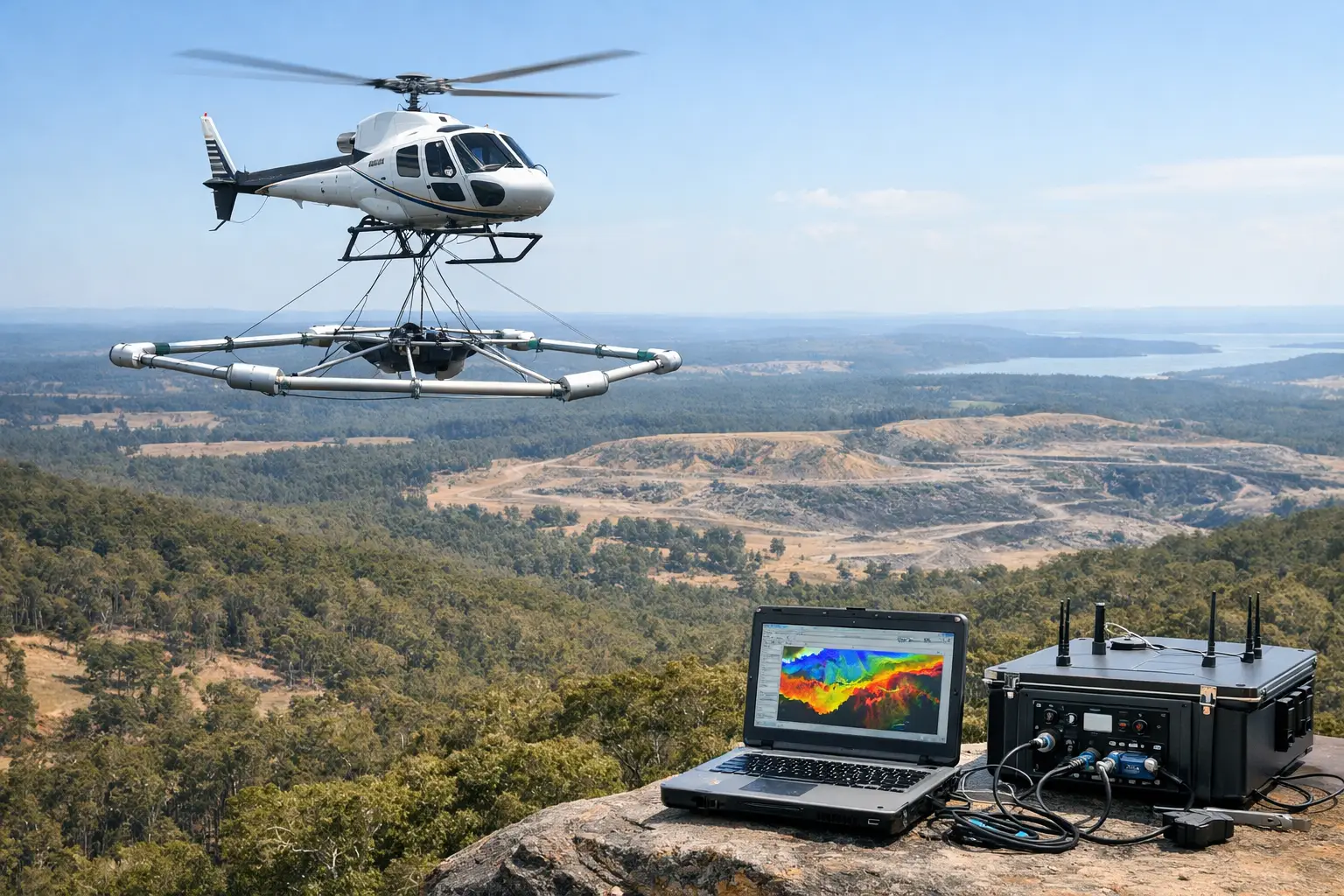
Airborne electromagnetics, or AEM, is a geophysical method that measures how the ground responds to an induced electromagnetic field. A transmitter mounted on an airborne platform generates a primary field. That field interacts with subsurface materials, which then produce a secondary response that is recorded by the receiver. The shape, timing, and decay of that response are used to estimate electrical conductivity with depth.
For technical buyers, the key point is straightforward: AEM does not detect geology directly. It detects contrasts in conductivity that often correlate with geology, groundwater salinity, clay content, alteration zones, structural controls, or buried infrastructure conditions. The value comes from interpretation, calibration, and integration with other datasets, not from the sensor alone.
That distinction matters in procurement. If the project objective is aquifer delineation, conductive overburden mapping, paleochannel detection, or mineral system targeting, AEM can be a high-yield method. If the objective depends on a property with weak conductivity contrast, or requires very high-resolution shallow engineering detail in congested terrain, a different or complementary method may be the better choice.
A guide to airborne electromagnetics for project planning
The first planning decision is not platform selection. It is target definition. The survey design has to match the conductivity structure you are trying to resolve, the expected depth of investigation, the terrain, and the decision that will rely on the data.
Time-domain AEM systems are often selected where deeper penetration and conductive target mapping are priorities. Frequency-domain systems can be effective for shallower investigations and specific engineering or environmental applications. The right configuration depends on formation resistivity, target size, cultural noise, and required resolution. There is no universally superior system. There is only fit-for-purpose design.
Platform choice also affects outcomes. Conventional crewed aircraft still serve large regional programs well, especially where coverage efficiency over very large extents is the main driver. Drone-based deployment changes the economics and operational profile for many projects, particularly where rapid mobilization, lower-altitude acquisition, repeat surveys, difficult access, or safety constraints are central. In remote desert terrain, narrow corridors, and smaller high-priority blocks, that flexibility can materially improve both schedule and data density.
Line spacing, flight altitude, and orientation should be treated as technical variables, not commercial placeholders. Wide line spacing may reduce cost, but it can also alias narrow conductors or degrade structural definition. Lower altitude usually strengthens signal quality, but it can increase operational complexity. Tie lines, calibration lines, and test segments are not administrative extras. They are part of the control framework that makes the output defensible.
Where airborne electromagnetics delivers the most value
In mineral exploration, AEM is commonly used to map conductive sulfide systems, alteration halos, regolith architecture, and basin or structural controls that influence ore emplacement. It is particularly useful in early-stage targeting, brownfield expansion, and license-wide screening where ground methods would be too slow or too fragmented. The strongest results usually come when conductivity data is fused with magnetics, radiometrics, geochemistry, and mapped geology.
In groundwater and water resource assessment, AEM can define aquifer geometry, salinity distribution, paleo-drainage, and confining layers over wide areas. That makes it attractive for wellfield planning, managed aquifer recharge studies, and regional hydrostratigraphic modeling. The method is powerful, but not automatic. Borehole control is still needed to calibrate inversion outputs and avoid overconfident interpretation.
For infrastructure and utilities, AEM can support route selection, corridor risk screening, and broad subsurface characterization where access is limited or timelines are compressed. It is less often a stand-alone engineering solution and more often a front-end intelligence layer that helps target follow-up geotechnical work. That distinction improves expectations and budget discipline.
Environmental applications include mapping leachate migration, salinity intrusion, and subsurface heterogeneity across difficult terrain. Here, repeatability and auditable processing are essential because project decisions may carry regulatory or public-sector scrutiny.
Data quality is where projects are won or lost
AEM programs succeed or fail on control, not promise. The acquisition phase has to account for transmitter stability, positional accuracy, platform motion, altitude control, noise sources, and terrain clearance. In industrial areas, cultural interference from powerlines, pipelines, fences, and operating facilities can materially affect data quality. If that is not addressed in planning and processing, the final model may appear detailed while remaining unreliable.
A disciplined workflow typically includes system calibration, diurnal monitoring where relevant, positional verification, flight path validation, noise screening, coupling analysis, and repeat-line assessment. These steps are not just technical formalities. They establish whether anomalies are geological, hydrological, or operational artifacts.
Processing and inversion then convert measured responses into conductivity-depth models. This is where many non-specialist buyers underestimate risk. Inversion is not a neutral step. The chosen constraints, starting models, regularization parameters, and assumptions about geology all influence the result. A smooth model may look coherent while masking sharp boundaries. A highly resolved model may exaggerate features that the data only weakly supports.
That is why interpreted deliverables matter more than raw sections or image outputs. Decision-makers need conductivity models tied to project questions, with uncertainty clearly stated and cross-validation against boreholes, geology, or other geophysical data wherever available. Air Solutions applies that standard because enterprise buyers are not purchasing pictures. They are purchasing traceable evidence for action.
What to ask before commissioning a survey
A serious buyer should ask what conductivity contrast is expected, what depth range matters, and what existing control data is available. They should also ask how the survey geometry was selected, how noise will be managed, how inversion will be constrained, and what level of interpretation is included in the scope.
Just as important, ask what the method will not resolve. If the provider cannot define likely limitations up front, the risk shifts to the client. In complex ground conditions, conductive cover can mask deeper responses. In resistive terrains, target detectability may depend heavily on survey altitude and system power. In active industrial corridors, cultural interference may limit confidence in certain zones. These are manageable constraints, but only if they are acknowledged early.
Commercially, the useful procurement question is not cost per line-kilometer alone. It is cost per decision improved. A lower survey price has limited value if poor design forces re-flying, leaves uncertainty unresolved, or produces outputs that cannot support technical sign-off.
How AEM fits into a multi-sensor program
The strongest airborne programs rarely rely on AEM in isolation. Electromagnetic data gains context when paired with aeromagnetics for structural mapping, LiDAR for terrain control, photogrammetry for surface conditions, and targeted ground verification. That integrated approach is especially effective in mining, groundwater, and linear infrastructure projects where multiple uncertainties interact.
AEM can tell you where conductivity changes. Magnetics can indicate lithology and structure. LiDAR can improve elevation control and drainage interpretation. Boreholes and sampling can anchor the geophysical model in physical evidence. When these layers are fused within a documented QA/QC framework, the result is not just more data. It is a more reliable basis for drilling, design, and investment sequencing.
When airborne electromagnetics is the wrong tool
A good guide to airborne electromagnetics should say this clearly: the method is not a solution for every subsurface problem. If the target lacks conductivity contrast, if site conditions are saturated with cultural noise, or if the required resolution is finer than the system can realistically achieve, another method may be more efficient. Ground EM, resistivity, seismic, GPR, or direct investigation can outperform airborne acquisition in specific settings.
The operational setting also matters. Weather windows, airspace restrictions, topographic relief, and regulatory approvals can affect program feasibility. Drone platforms improve flexibility, but they do not eliminate the need for disciplined mission planning, permitting, and field control.
That is why the best AEM projects begin with a technical scoping discussion, not a generic quote request. When objectives, geology, constraints, and decision thresholds are defined at the start, airborne electromagnetics becomes what it should be - a calibrated, auditable, and commercially efficient way to reduce uncertainty at scale.
If your next project depends on seeing below surface assumptions rather than around them, the right survey is the one that turns geophysics into a defendable decision, not just a deliverable.