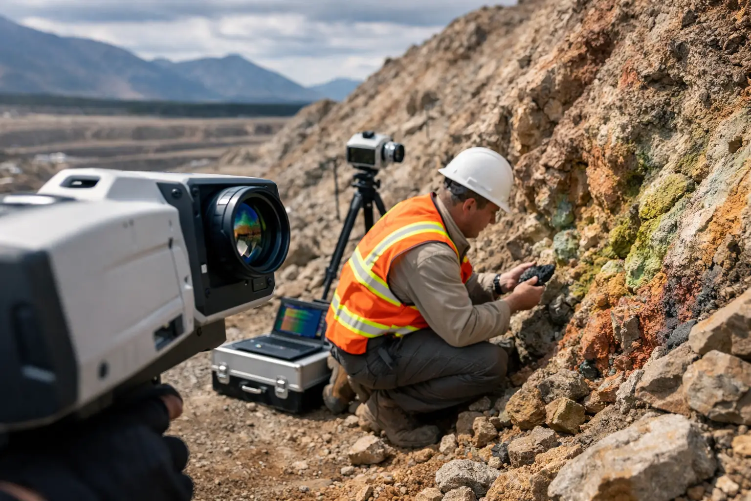
A drill program can miss the most useful part of an alteration system if the targeting model is built on sparse mapping and broad lithologic assumptions. That is where understanding how hyperspectral surveys find alteration becomes commercially significant. Instead of inferring mineralogical change from limited samples, hyperspectral data measures reflected energy across many narrow spectral bands and identifies surface mineral responses directly, at survey scale.
For exploration managers, principal geologists, and technical procurement teams, the value is not the imagery itself. The value is a calibrated mineral map that shows where hydrothermal processes changed the host rock, how those changes are zoned, and whether the pattern supports a larger mineral system. In practical terms, hyperspectral surveys reduce uncertainty between field observation and drilling, especially across large, remote, or structurally complex ground.
How hyperspectral surveys find alteration in practice
Hyperspectral sensing works because many alteration minerals absorb and reflect light in diagnostic ways. Minerals such as muscovite, illite, kaolinite, alunite, chlorite, epidote, calcite, and hematite each produce distinctive spectral features, particularly in the visible, near-infrared, and shortwave infrared ranges. When a calibrated airborne sensor records hundreds of contiguous spectral bands, those absorption features can be measured and classified.
That is the core of how hyperspectral surveys find alteration. The survey does not detect alteration as a generic condition. It detects mineral assemblages and spectral shifts that are consistent with alteration styles. If white mica chemistry changes across a system, or chlorite and epidote become more dominant along a structural corridor, the spectral response can indicate that transition before a single trench is cut.
This matters because alteration is often a better vector than lithology alone. In porphyry, epithermal, IOCG, and VMS settings, the geometry and mineralogy of alteration halos often provide the strongest clues to fluid pathways and mineralization centers. A properly processed hyperspectral dataset can therefore move target generation from broad interpretation to mineral-specific mapping.
The survey chain that turns spectra into geology
The sensing stage is only the front end. Decision-grade outputs depend on a controlled workflow from acquisition through interpretation.
Sensor acquisition and calibration
An airborne hyperspectral sensor records reflected energy in narrow spectral intervals. For the data to be usable, the system must be radiometrically stable, geometrically accurate, and synchronized with navigation data. Flight planning is not trivial. Sun angle, terrain shadow, line spacing, altitude, ground sampling distance, and atmospheric conditions all affect data quality.
In desert environments, bright surfaces and strong illumination can improve signal quality, but they can also introduce complications from albedo contrast, dust, and heat loading. That is why disciplined field procedures matter. Raw spectral data without calibration is not a mineral map. It is only a starting point.
Atmospheric correction and reflectance generation
Before interpretation, the dataset is corrected to convert sensor-recorded radiance into surface reflectance. This step removes atmospheric effects and normalizes the data so mineral absorption features can be compared consistently across the survey block. If this stage is weak, downstream mineral identification becomes unreliable.
At enterprise level, teams should expect traceable correction methods, documented assumptions, and QA/QC records. Alteration mapping that cannot be audited back to processing decisions is difficult to defend in technical reviews or investment committees.
Spectral classification and mineral identification
Once reflectance is generated, spectral analysis compares each pixel to known mineral libraries and feature-based models. This can be done through spectral angle methods, absorption-feature fitting, unmixing approaches, and supervised or rule-based classification. The objective is not simply to label pixels, but to identify meaningful mineral distributions with known uncertainty.
This is where geoscience judgment becomes essential. Some minerals have overlapping features. Grain size, coatings, weathering, and mixed pixels can distort signatures. Carbonate-rich surfaces may mask weaker signals. Iron oxides may dominate visible responses while clay minerals carry the real alteration story in shortwave infrared bands. A disciplined interpretation workflow separates direct detections from inferred alteration associations.
What alteration styles hyperspectral data can reveal
Hyperspectral surveys are especially effective where hydrothermal mineralogy is exposed or weakly covered. They are commonly used to map argillic, advanced argillic, phyllic, propylitic, and iron-rich alteration domains.
In a porphyry environment, for example, white mica composition may vary outward from the core, while chlorite-epidote assemblages define propylitic halos and silica-rich zones indicate structurally focused fluids. In high-sulfidation epithermal systems, alunite, kaolinite, dickite, and silica can help separate steam-heated alteration from more prospective feeder structures. In skarn or carbonate replacement contexts, calc-silicate mineral distributions and iron responses may help prioritize structural contacts and intrusive margins.
Still, it depends on exposure. Hyperspectral surveys map what the sensor can see. Thick alluvium, transported cover, vegetation, urban clutter, and surface contamination can limit detection. That does not make the method less useful. It means the dataset should be integrated with magnetics, electromagnetics, radiometrics, structural mapping, and geochemistry rather than treated as a standalone answer.
Why alteration mapping is stronger when fused with other datasets
No serious exploration program should rely on one sensor class to carry the full targeting model. Hyperspectral data is strongest when it is cross-validated against geophysics, topography, and field control.
If a white mica anomaly aligns with a magnetic destruction zone, a lineament corridor, and mapped quartz veining, confidence rises. If kaolinite appears across a broad low-relief plain with no structural support and no geochemical response, the anomaly may reflect weathering rather than hydrothermal alteration. The distinction matters because it affects drill placement, budget allocation, and project timing.
This is where multi-sensor execution has operational value. Fused datasets allow geologists to separate alteration caused by mineral systems from alteration caused by surface processes, lithologic weathering, or false spectral positives. For institutional buyers, that means fewer isolated maps and more defensible targeting products.
How hyperspectral surveys find alteration faster than conventional mapping
Traditional alteration mapping relies on traverses, selective sampling, petrography, and lab spectroscopy. Those methods are still necessary, but they are spatially limited and time-intensive. Hyperspectral airborne surveys cover large areas quickly and generate continuous mineralogical information across the entire survey block.
That speed changes project economics. A team can screen regional tenure, rank prospects, refine field programs, and focus ground verification on the most meaningful mineral transitions. In harsh operating environments, the reduction in ground exposure also matters. Fewer field days in difficult terrain means lower HSE risk and better schedule control.
The trade-off is resolution versus certainty. Airborne hyperspectral data gives broad spatial continuity, but laboratory analysis still provides higher-confidence mineral identification at sample scale. The most effective workflow uses airborne results to guide fieldwork, then uses field and lab data to refine the interpretation model.
Common limitations technical teams should evaluate
Buyers should ask direct questions before commissioning a survey. What spectral range is being captured? What minerals are realistic targets in this geologic setting? How will atmospheric correction be validated? What ground truth is planned? What confidence thresholds will be used in classification? How will mixed pixels and shadow be treated?
These questions matter because not every alteration system is equally detectable. Surface varnish, moisture, salt crusts, and weathering rinds can distort signatures. In some terrains, iron oxide mapping may be strong while clay discrimination is weaker. In others, topographic shadow or thin surficial cover may reduce interpretability even when the sensor performs correctly.
A disciplined provider will state those constraints clearly and define where the data is definitive, where it is interpretive, and where field validation is mandatory. That level of transparency is part of what makes the output usable in procurement reviews, technical boards, and downstream investment decisions.
What decision-makers should expect from deliverables
For enterprise use, the output should extend beyond false-color images. The useful deliverable is an interpreted package: mineral distribution maps, alteration domain polygons, spectral anomaly layers, confidence metrics, processing documentation, and integration with geology and other geophysical datasets. The result should be structured for direct use in GIS, targeting workshops, and reporting workflows.
That is especially relevant in large-scale programs across Saudi Arabia and the Gulf, where rapid mobilization, harsh environmental conditions, and auditability are not optional. Providers such as Air Solutions position hyperspectral work within a broader geospatial intelligence framework because the commercial decision is rarely about one sensor. It is about whether the final interpreted product is reliable enough to move a project forward.
When hyperspectral data is well acquired, well processed, and properly integrated, alteration mapping becomes more than a visual aid. It becomes a vectoring tool. The strongest programs use it to ask sharper geologic questions, eliminate weaker targets earlier, and commit field budgets where the mineral system evidence is strongest. That is usually where better decisions begin.