A failed water well is rarely just a drilling problem. It is usually a targeting problem upstream - weak subsurface control, incomplete terrain intelligence, or a survey design that does not match the hydrogeology. That is why a strong groundwater prospecting project example matters to project owners, hydrologists, and procurement teams. It shows how decision-grade targeting is built before a rig ever mobilizes.
For institutional buyers, the value is not in raw geophysical coverage alone. The value is in a traceable workflow that narrows uncertainty, ranks drill targets, and produces outputs that can stand up to technical review, budget scrutiny, and regulatory oversight. In arid settings across Saudi Arabia and the wider Gulf, where access, heat, and time pressure shape field operations, that discipline becomes even more important.
Groundwater prospecting project example: project objective
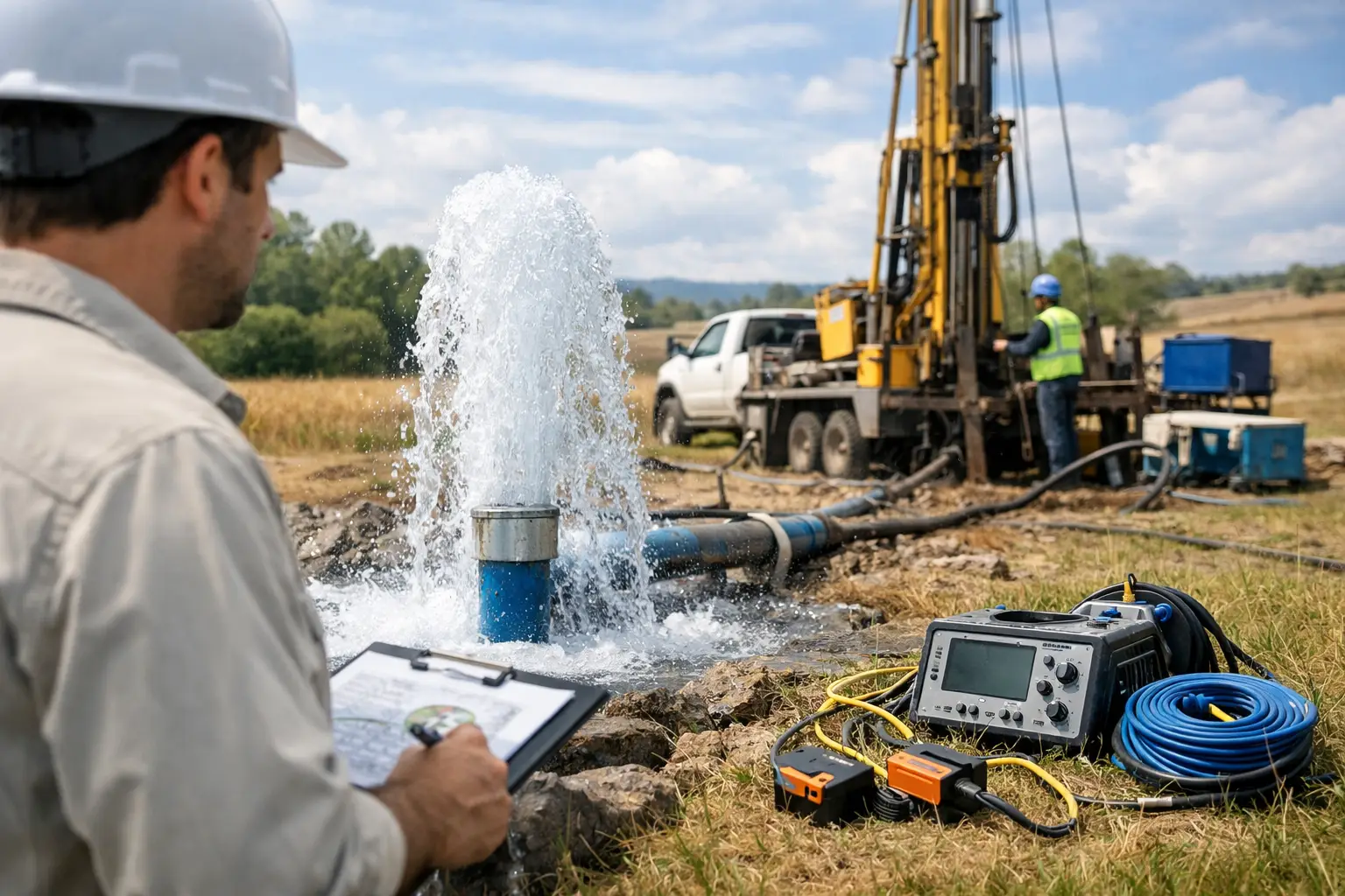
Consider a 120-square-kilometer assessment area on a remote plateau margin with fractured basement geology overlain by variable alluvium. The client objective is straightforward but high consequence: identify priority groundwater targets to support industrial water supply planning, reduce non-productive drilling, and establish a defensible basis for follow-on test wells.
Existing information is limited. There are regional geological maps, scattered borehole logs of mixed quality, a small number of historical pumping test records, and satellite-derived lineament interpretations that have not been field-validated. Surface access is uneven, and some areas are logistically inefficient for dense ground geophysics. The client needs a faster method that can screen the full block, isolate favorable structures, and convert multi-sensor data into interpretable hydrogeological targets.
Survey design and acquisition logic
In this type of groundwater prospecting project example, survey design is driven by the hydrogeological model rather than by sensor availability alone. If the working hypothesis is that groundwater occurrence is controlled by fracture corridors, weathered bedrock thickness, and localized alluvial accumulation, then the acquisition plan has to resolve each of those elements with enough confidence to support ranking.
A practical drone-based scope would combine airborne magnetics, electromagnetic data where conductive contrasts are expected to be meaningful, high-resolution elevation data, and calibrated optical products for structural and geomorphological mapping. Each dataset answers a different question. Magnetics helps map basement architecture and lineaments. Electromagnetics can help detect weathered zones, saturated alluvium, or conductivity changes associated with clay, salinity, or moisture. Elevation and terrain derivatives clarify drainage behavior, recharge pathways, and subtle structural expression at surface.
Flight lines are oriented to maximize sensitivity to the dominant structural grain while maintaining adequate tie-line control for leveling and QA/QC. In a desert operational context, this also means planning around wind windows, thermal loading, launch recovery constraints, and battery rotation efficiency. Speed matters, but repeatability matters more. If datasets cannot be cross-validated, they do not reduce decision risk.
Data processing, QA/QC, and traceability
The difference between usable and non-usable survey output often appears after acquisition. A technically sound groundwater program requires calibrated sensors, documented processing parameters, and a QA/QC chain that is fully auditable.
Magnetic data would typically be corrected, leveled, and filtered to isolate structural features relevant to groundwater storage and flow. Electromagnetic data would be processed with careful attention to noise rejection, altitude variation, and inversion stability. Terrain products would be checked against ground control or verified positional standards so that structural picks and hydrological features align spatially across the stack.
This is where many prospecting programs lose value. A map may look convincing, but if lineaments from magnetics do not spatially correlate with topographic breaks, drainage anomalies, or field observations, confidence drops quickly. Cross-validation is the control point. Interpreters should be able to show why a target exists, which datasets support it, and where uncertainty remains.
For enterprise and government buyers, that traceability is not a reporting detail. It is a commercial requirement. If a drilling recommendation drives capital allocation, contractor mobilization, and water infrastructure planning, the subsurface case must be documented in a way that technical reviewers can interrogate.
Interpreting the target model
Once the data is processed, the project shifts from mapping to ranking. In a representative groundwater prospecting project example, interpreters might identify three target classes rather than a single "best" location.
The first class could be major fracture intersections in shallow basement highs where recharge pathways are structurally focused. These targets may offer good transmissivity in competent fractured rock, but yield depends heavily on fracture connectivity. They can be attractive, though they carry geological variability.
The second class could be weathered basement troughs with moderate conductivity response and geomorphic evidence of runoff concentration. These zones may provide more predictable storage conditions, especially where saprolite development is thick enough to retain water but not so clay-rich that permeability collapses.
The third class could be buried alluvial channels along the plateau margin. These often present a strong operational case because drilling is easier and completion costs can be lower. The trade-off is water quality and seasonal reliability. Conductive signatures in alluvium may indicate saturated material, but they may also reflect salinity or clay content. Without integrated interpretation, those targets can be overrated.
A disciplined target ranking matrix would therefore score each candidate location against structural favorability, conductivity response, topographic setting, recharge potential, access constraints, and expected drilling risk. The final deliverable is not just a map with circles. It is a prioritized drilling program with technical rationale.
What the deliverables look like
For a client making investment or planning decisions, the most useful outputs are concise and decision-oriented. A mature project package would typically include interpreted structural maps, conductivity depth sections or inversion products, digital terrain models, target ranking tables, acquisition and processing notes, and a recommendation set for follow-up verification.
The reporting format should separate observation from interpretation. For example, it should distinguish a mapped magnetic lineament from the interpreted conclusion that the lineament may represent a fracture-controlled groundwater pathway. That distinction is essential for credibility. It allows the client team, whether internal or third-party, to review the evidence chain rather than accept unsupported claims.
Air Solutions typically structures this kind of work around interpreted geospatial intelligence rather than raw sensor delivery alone. That distinction matters because most clients do not need more unfiltered data. They need calibrated, processed, and sector-aligned outputs that can move directly into drilling, planning, or feasibility workflows.
Follow-on ground verification
No serious groundwater prospecting program should imply that airborne data eliminates the need for ground truth. It reduces the search space and improves targeting efficiency, but final drill decisions should still be verified through focused follow-up work.
Depending on the site, that may include electrical resistivity tomography, passive seismic, field structural mapping, shallow test pits in alluvium, or direct validation against known wells. The point is not to repeat the airborne survey from the ground. The point is to apply higher-detail ground methods only where the airborne interpretation has already concentrated the probability of success.
This staged model is usually where cost efficiency appears. Instead of running slow, dense ground profiles across the entire concession or development block, the team uses airborne screening to cut the footprint down to a manageable set of priority corridors. That reduces field exposure, shortens mobilization timelines, and produces a cleaner technical basis for procurement and drilling authorization.
Where this approach works best - and where it does not
A drone-enabled groundwater workflow is strongest in large or difficult areas where rapid coverage, high-resolution structural mapping, and flexible mobilization deliver a clear advantage over conventional methods. It is especially effective in remote terrain, fractured rock settings, and early-stage basin screening where the client needs to move from broad uncertainty to ranked targets quickly.
It is less decisive where hydrogeology is controlled by very localized shallow heterogeneity that falls below the resolving power of the selected airborne method, or where conductive responses are ambiguous because salinity and clay produce similar signatures. In those cases, interpretation must be conservative. Better data is not the same as perfect certainty.
That trade-off is exactly why the best groundwater prospecting project example is not the one with the most colorful maps. It is the one with the clearest decision logic, the strongest QA/QC discipline, and the most honest treatment of uncertainty. When the subsurface case is built that way, drilling becomes a targeted engineering decision rather than a speculative search.
The practical test is simple: if your survey outputs can tell a technical committee not only where to drill, but why that target outranks the alternatives and what could still go wrong, the project has done its job.