A utility strike does not usually start with excavation. It starts earlier, when an asset register is incomplete, a corridor has shifted over time, or a survey method is selected for speed instead of detection physics. That is why the question, can drones detect buried utilities, matters at the planning stage rather than after a field incident. For infrastructure owners, EPC contractors, and public agencies, the real issue is not whether a drone can "see through the ground" in a simple sense. It is whether a drone-based survey can generate defensible evidence of buried linear assets under actual site conditions.
Can drones detect buried utilities in real projects?
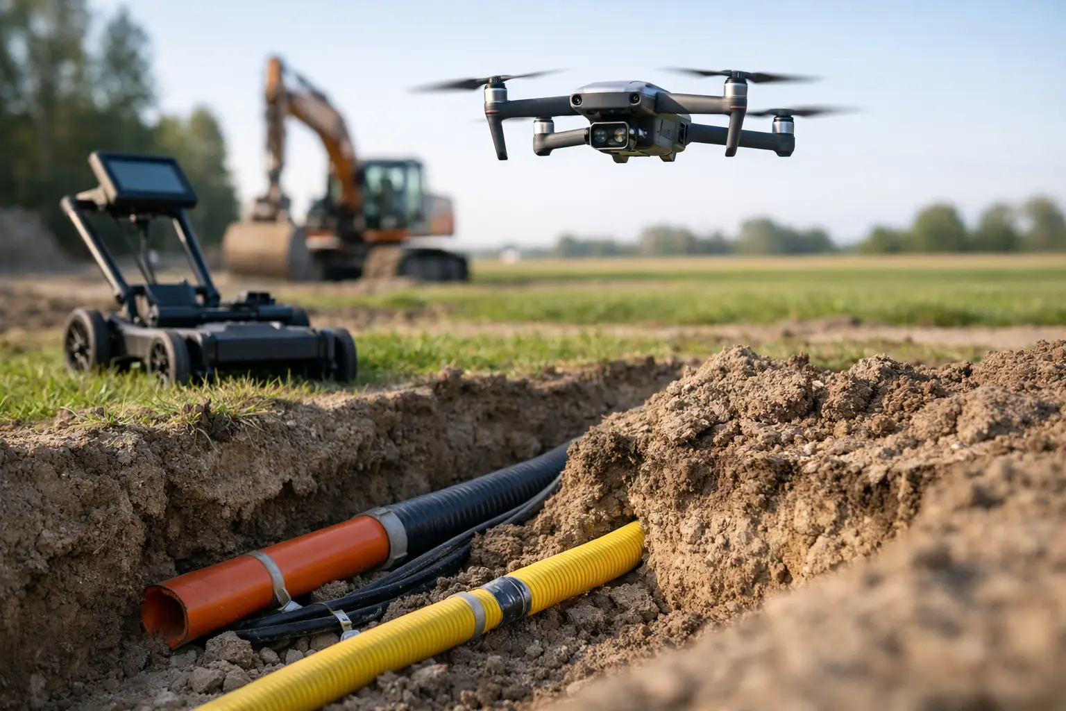
Yes, but only under specific technical conditions and only with the right sensor stack. A drone by itself does not detect underground utilities. The outcome depends on the sensing modality, target material, burial depth, soil conductivity, surface interference, and the quality of data processing and interpretation.
This distinction matters because buried utilities are not a single detection problem. Metallic pipelines, energized cables, non-metallic conduits, concrete culverts, and abandoned lines each respond differently to geophysical methods. In many projects, the most accurate answer is not a binary yes or no. It is a probability-based assessment built from multiple datasets that are calibrated, cross-validated, and tied to ground control.
For enterprise buyers, that means drone utility detection should be treated as a geospatial intelligence workflow, not a gadget-led survey. When properly designed, drones can improve coverage rates, access constraints, safety, and repeatability. They can also reduce the amount of blind ground investigation required before engineering design or construction mobilization.
What drones can actually measure
Drone platforms are carriers for sensors. In buried utility work, the relevant question is which physical properties those sensors can detect indirectly from the air. The most common useful signals are magnetic anomalies, electromagnetic response, surface topographic evidence, thermal contrast in limited cases, and spectral or moisture-related surface indicators that correlate with subsurface disturbance.
Aeromagnetic systems can detect ferrous utilities or infrastructure components that create measurable magnetic contrasts against background geology and cultural noise. This is often effective for steel pipelines, legacy well infrastructure, or buried metallic debris fields that complicate corridor development. Electromagnetic systems can help identify conductive targets and subsurface contrasts, though performance is highly dependent on terrain, conductivity structure, and flight configuration.
LiDAR and photogrammetry do not detect utilities directly, but they are operationally critical. They map microtopography, settlement traces, trench lines, disturbed ground, access corridors, and as-built terrain conditions with high spatial fidelity. In utility corridor intelligence, these datasets often explain where a buried asset is likely to be, even when geophysical evidence remains partial.
Ground penetrating radar is often mentioned in the same conversation. It is excellent in the right environment, especially for shallow utility mapping, but it is typically a ground-based method rather than an airborne one. The constraint is physics and standoff distance. If a client needs confirmed shallow locates in congested urban settings, drone geophysics may narrow the search area, but ground methods usually complete the utility designation.
Where drone detection performs well
The strongest use case is linear infrastructure over large or difficult terrain. Pipeline corridors, transmission routes, desert utility alignments, remote industrial expansions, and pre-construction greenfield sites are all well suited to drone-based screening. In these environments, manned aircraft can be costly to mobilize and ground crews can be slow, exposed, or restricted by access.
Drone surveys are also valuable where records are fragmented or where historical construction predates current GIS standards. A calibrated magnetic or electromagnetic survey can identify anomalies that justify targeted verification before trenching, piling, or route redesign. That is a very different value proposition from promising exact utility maps from the air alone. It is about reducing uncertainty in a controlled way.
In arid regions, performance can improve for some methods because sparse vegetation and dry surface conditions simplify line planning and reduce some forms of signal interference. At the same time, desert operations introduce their own controls around calibration stability, thermal loading, dust ingress, and quality assurance. High-performance results come from disciplined acquisition and processing, not from favorable weather alone.
Where the limits are non-negotiable
This is where many oversimplified claims fail. Non-metallic utilities are harder to detect unless they create secondary indicators such as disturbed trench backfill, moisture anomalies, or associated metallic markers. Deep burial reduces detectability. Dense urban environments introduce magnetic clutter, electromagnetic noise, reinforced concrete, traffic, fencing, and surface infrastructure that can mask the target signal.
Wet clay soils can degrade some methods. Saline conditions can complicate electromagnetic interpretation. Congested utility corridors can generate overlapping anomalies that are not resolvable to engineering tolerance without direct ground follow-up. If a project requires centimeter-level designation of multiple shallow services beneath reinforced pavement, a drone survey alone is unlikely to satisfy that requirement.
There is also a data governance issue. Detection is not the same as confirmation. A geophysical anomaly may indicate a utility, but unless it is correlated with records, known tie points, potholing, ground geophysics, or as-built evidence, it remains an interpreted target. Serious operators make that distinction explicit in the deliverable.
Can drones detect buried utilities better than ground crews?
Better is the wrong comparison. More efficient at corridor-scale screening, often yes. Better for final designation of shallow congested services, not necessarily. Ground crews with electromagnetic locators and GPR have the advantage of proximity and can often resolve shallow assets more precisely in controlled conditions. Drone systems have the advantage of speed, access, repeatability, and broad-area context.
The most effective programs combine both. A drone survey can rapidly identify priority zones, anomaly clusters, undocumented lineaments, and terrain factors across kilometers of corridor. Ground teams then verify the highest-risk locations. This staged workflow usually produces a stronger commercial outcome than relying on either method in isolation.
For clients managing schedule pressure, this hybrid model is often the difference between a controlled pre-construction investigation and reactive utility conflict management after mobilization.
The survey design determines the answer
If the objective is simply to ask whether buried infrastructure may exist in a project area, a reconnaissance-level airborne geophysical survey may be sufficient. If the objective is to support engineering design, route optimization, or excavation permits, the survey design has to be much tighter.
That means defining the target utility classes, expected depth range, host ground conditions, corridor width, line spacing, sensor altitude, calibration procedures, and validation plan before mobilization. It also means deciding what the final deliverable must support. Risk screening, route selection, utility conflict assessment, and construction clearance all require different confidence thresholds.
This is where specialized providers differentiate themselves. The technical value is not just in operating a drone. It is in selecting the right acquisition geometry, maintaining sensor calibration, correcting for platform motion, filtering cultural noise, and producing interpreted outputs that can stand up to procurement, engineering, and audit review. Air Solutions operates in exactly that discipline, where multi-sensor fusion and traceable QA/QC convert airborne measurements into decision-grade geospatial products.
What a defensible deliverable should include
A credible buried utility investigation from drone data should not stop at anomaly maps. It should define acquisition parameters, site conditions, control methods, processing steps, interpretation criteria, and confidence limits. It should separate detected anomalies, probable utilities, and verified assets. Where possible, it should integrate legacy records, topographic mapping, and any available ground-truth observations.
For infrastructure owners and public agencies, auditable reporting is as important as detection performance. Project teams need to know what was measured, what was inferred, what remains uncertain, and where follow-up investigation is mandatory. That level of discipline protects both safety outcomes and procurement defensibility.
It also enables a more rational allocation of field resources. Instead of sending ground crews across an entire corridor, teams can concentrate on ranked targets with a documented basis for prioritization.
The practical answer for buyers
So, can drones detect buried utilities? Yes, in the right setting and with the right sensing strategy. They are particularly effective for large-area screening, remote corridor intelligence, metallic asset detection, and reducing uncertainty before intrusive work begins. No, they are not a universal replacement for every ground-based locate method, especially in dense urban environments or where shallow non-metallic services must be designated with high precision.
For procurement and technical evaluation teams, the more useful question is this: what portion of the buried utility risk can be retired from the air before ground crews are deployed? When that question is framed correctly, drone surveys become a powerful part of a phased utility intelligence program rather than an overclaimed substitute for all subsurface investigation.
The projects that benefit most are the ones that respect both the capability and the limits of the method. If buried utility risk carries schedule, safety, or capital exposure, the smartest next step is not to ask for a generic drone survey. It is to commission a survey design that matches the physics of the site and the decision that has to be made.