A survey program that performs well in temperate terrain can fail quickly in open desert. Windborne dust degrades optics, heat affects battery behavior and sensor stability, sparse ground control complicates validation, and long access routes turn simple mobilization into a cost and safety issue. That is why an airborne survey for desert environments has to be engineered as an operational system, not treated as a standard aerial campaign moved into sand.
For project owners in mining, water, utilities, and major infrastructure, the central question is not whether airborne methods work in desert conditions. They do. The real question is which sensing stack, flight design, calibration protocol, and QA/QC framework will produce decision-grade outputs under high heat, low contrast, and limited site accessibility. In that setting, aircraft selection matters, but methodology matters more.
What makes an airborne survey for desert environments different
Desert terrain creates a combination of operational and geophysical constraints that are easy to underestimate from a desktop plan. Surface reflectance can be extreme. Dune fields shift. Topographic relief may appear low, yet line-of-sight communications, launch windows, and landing zones can still be constrained by remoteness and loose substrate. In exploration corridors and infrastructure concessions, there is often limited preexisting mapping at the resolution required for engineering or subsurface targeting.
These conditions change how a survey should be designed. Sensor altitude, line spacing, overlap, base station configuration, and calibration frequency all need adjustment to maintain data integrity. A photogrammetry mission over a rock outcrop belt requires different settings than a LiDAR campaign over low-feature sand, and both differ again from an aeromagnetic or electromagnetic program intended to map structure, conductive targets, or groundwater pathways beneath cover.
The key point is that desert work punishes generic workflows. Reliable acquisition comes from matching platform, sensor, and processing logic to the physical behavior of the site.
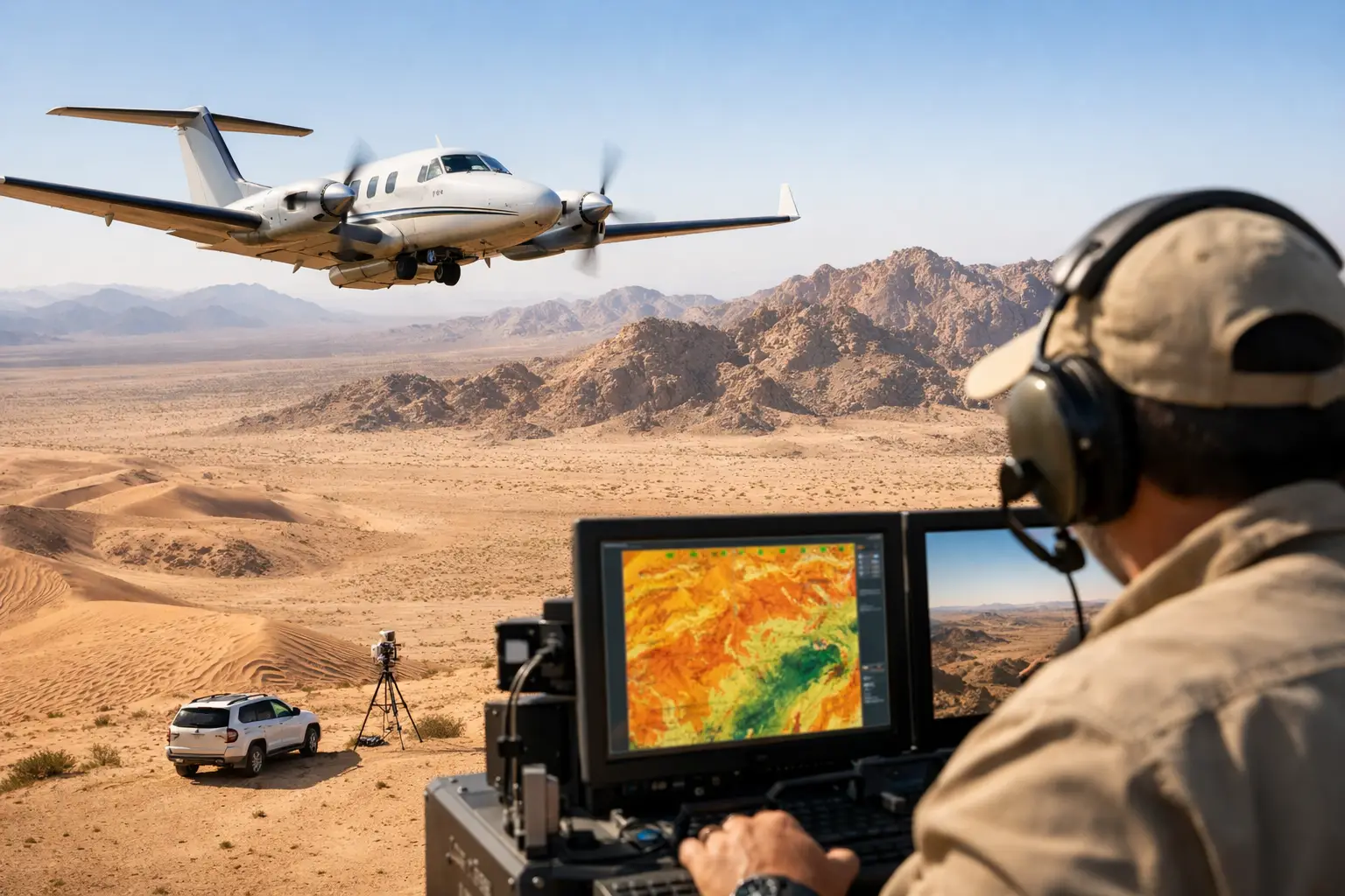
Sensor selection in desert survey operations
No single payload solves every desert problem. The most effective airborne survey for desert environments usually combines multiple sensing modalities and reconciles them during processing and interpretation.
LiDAR is often the preferred tool where terrain definition is critical and surface texture is too uniform for stable photogrammetric tie points. In wadi systems, escarpments, haul road planning, and corridor engineering, LiDAR maintains performance where image-only workflows may struggle. It also supports volumetric analysis and terrain modeling with a higher level of consistency in low-contrast ground conditions.
Photogrammetry remains valuable when the objective includes high-resolution orthomosaics, visual inspection, and cost-efficient surface mapping across large blocks. Its performance improves substantially when flight timing, sun angle, control strategy, and camera calibration are planned specifically for desert reflectivity and shadow behavior.
Aeromagnetic surveying is particularly effective across mineral exploration ground where structural mapping beneath shallow cover is required. In desert provinces, sparse vegetation can be an advantage, but thermal drift, platform interference, and heading effects still demand disciplined compensation and validation. Electromagnetic surveys add another layer where conductivity contrasts are relevant for groundwater exploration, regolith characterization, salinity studies, or mineral system mapping.
Hyperspectral and radiometric methods also have a role, especially in alteration mapping, material discrimination, and surface geochemistry screening. Their usefulness depends heavily on atmospheric correction, spectral calibration, and the mineralogical context of the target area. In harsh desert light, poor acquisition discipline can reduce them to attractive images with limited technical value.
Operations discipline matters more than airframe marketing
Enterprise buyers are often presented with claims about endurance, payload, or speed. Those metrics matter, but they do not replace field discipline. In desert operations, mission success depends on repeatability.
That starts before launch. Sensor warm-up periods must be controlled. Calibration flights need to be documented. GNSS base station placement and timing have to be traceable. Dust management around takeoff and landing areas affects both equipment reliability and data quality. Heat exposure windows must be planned around the actual thermal limits of the platform and payload, not brochure values.
It continues in flight. Line spacing has to reflect the target depth, required resolution, and the physics of the sensing method. Terrain following must be stable. Cross-lines are not optional if the objective is a fully auditable dataset. In remote desert blocks, communications and contingency planning also become a technical issue, because incomplete line capture or inconsistent altitude control can compromise interpretation.
For this reason, the best operator is rarely the one with the largest drone. It is the one with the most controlled acquisition framework.
QA/QC is the difference between imagery and intelligence
Desert clients do not commission surveys to collect attractive visuals. They commission surveys to reduce uncertainty in decisions that carry large capital, regulatory, and schedule consequences. That requires QA/QC that is visible, documented, and defensible.
A credible workflow includes sensor calibration records, flight logs, positional accuracy checks, overlap verification, line-level review, noise assessment, and cross-validation against ground truth or historical datasets where available. For geophysical campaigns, that extends to leveling, diurnal correction, heading correction, tie-line analysis, and anomaly discrimination. For terrain and imaging programs, it includes checkpoint residuals, point cloud classification review, and orthomosaic consistency assessment.
Processed outputs should also be tailored to use case. A principal geologist requires interpreted structure, alteration trends, and target ranking logic, not just magnetic grids. An EPC contractor needs surface models, corridor constraints, and utility conflict visibility. A water resources team needs hydrogeologic indicators framed in operational terms. Raw data has value, but interpreted deliverables are what support procurement, planning, and investment decisions.
This is where specialist providers separate themselves from low-cost flight contractors. Data without interpretation shifts risk back to the client.
Where airborne survey for desert environments creates the most value
In mining and exploration, airborne methods compress the time between concession access and target definition. They help map lithology, structure, shallow cover, and access terrain across large license areas without the delay and exposure associated with dense ground traverses. In early-stage programs, this improves target screening. In advanced programs, it sharpens drill planning and reduces wasted follow-up.
In groundwater and environmental work, the value is different. Desert hydrology is often controlled by subtle structural and sedimentary features that are not obvious at surface. Electromagnetic, radiometric, topographic, and multispectral data can be integrated to identify recharge zones, paleochannels, fracture corridors, and salinity patterns. The result is a stronger basis for borehole planning, monitoring design, and resource management.
For utilities and linear infrastructure, rapid airborne acquisition supports route optimization, grading analysis, drainage assessment, and conflict identification across long corridors. In remote build environments, reducing repeated field mobilization has direct cost and safety benefits. It also helps maintain schedule certainty when project teams need current terrain intelligence rather than outdated basemaps.
Government-backed development programs and national infrastructure initiatives place an additional premium on auditability. Survey outputs may feed procurement packages, regulatory submissions, or multi-stakeholder planning frameworks. In those cases, the requirement is not only accuracy. It is traceability from acquisition to interpreted product.
Trade-offs buyers should evaluate before procurement
Faster is not always better. Wide-area coverage at aggressive altitude may reduce acquisition time, but it can also weaken the resolution needed for engineering or geoscience interpretation. Similarly, the lowest-cost proposal may exclude the calibration, cross-lines, or interpretive steps needed to make the dataset dependable.
There is also a practical trade-off between single-sensor simplicity and multi-sensor value. A focused LiDAR or magnetic campaign may be the right answer when the problem is narrow and well defined. But in many desert projects, the highest return comes from fusing terrain, imaging, and geophysics so that surface and subsurface evidence can be cross-validated. That increases planning complexity, yet it often lowers total project uncertainty.
Procurement teams should also examine what is being delivered. If the scope ends at raw point clouds, raster outputs, or uncontextualized grids, internal teams must absorb the interpretation burden. A provider such as Air Solutions is better aligned to enterprise requirements when the engagement includes processed, validated, and sector-specific intelligence products ready for technical and executive use.
Why this model fits Gulf-region project delivery
Desert projects in Saudi Arabia and the wider Gulf are often large, schedule-sensitive, and operationally constrained. They may involve remote concessions, national infrastructure corridors, water security priorities, or high-value industrial expansion tied to Vision 2030. In that environment, survey methods must mobilize quickly, operate safely, and produce outputs that stand up to technical scrutiny.
Drone-based airborne systems are well suited to that requirement when they are deployed with the rigor normally associated with much larger survey programs. They reduce field exposure, shorten acquisition cycles, and provide access to areas where ground methods are slow or manned-aircraft economics are difficult to justify. More importantly, they can produce calibrated, cross-validated datasets that move directly into engineering, exploration, and planning workflows.
The strongest airborne survey programs in desert settings are not defined by hardware alone. They are defined by whether the final deliverable can withstand review from geologists, engineers, procurement teams, and regulators at the same time. That is the standard worth buying against, especially when the next decision carries far more value than the survey itself.