A utility strike rarely starts with excavation. It starts earlier - with incomplete records, the wrong sensor selection, or a survey scope that treats all buried assets as if they respond the same way. Utility detection survey methods exist to reduce that uncertainty, but the right method depends on what is buried, how deep it sits, the surrounding ground conditions, and the level of decision confidence the project actually requires.
For infrastructure owners, EPC contractors, and public-sector planners, the real question is not which technology sounds most advanced. It is which survey design will produce auditable, decision-grade subsurface intelligence with acceptable risk, within the project timeline, and under site-specific operating constraints.
What utility detection survey methods are designed to solve
Utility detection is not a single task. It usually combines locating, tracing, depth estimation, classification, and conflict assessment. On a brownfield site, those objectives may also include reconciling legacy records against field evidence. On a corridor or megaproject footprint, the objective often shifts toward defining subsurface congestion before design freeze, trenching, or piling begins.
That distinction matters because different utility detection survey methods answer different questions. Some methods are strong at tracing conductive lines over distance. Others are better at identifying non-metallic features, voids, or buried structures that do not produce a clear electromagnetic response. Some perform well in open corridors and poorly inside reinforced urban hardscape. Others are ideal for rapid screening but not for final engineering setout.
A disciplined survey program starts by defining the decision threshold. If the deliverable must support permit applications, design coordination, construction sequencing, or claims defense, the methodology needs traceability, calibration records, positional control, and cross-validation between sensing modalities.
Core utility detection survey methods in current practice
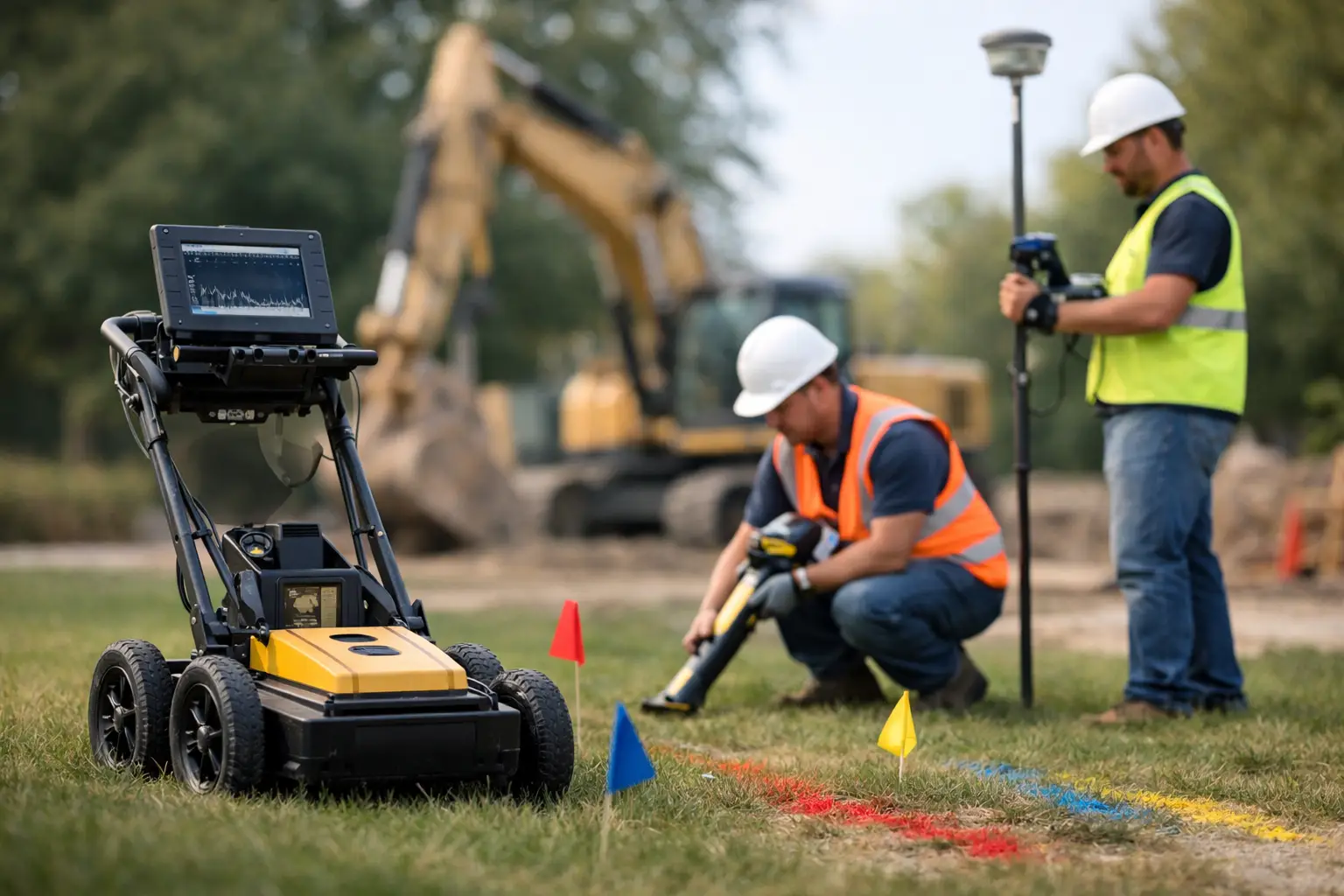
Ground penetrating radar remains one of the most widely used techniques because it can detect both metallic and non-metallic buried features. It transmits electromagnetic pulses into the ground and interprets reflected signals from subsurface interfaces. In favorable conditions, GPR can identify plastic pipes, concrete ducts, abandoned lines, and other buried objects that a standard electromagnetic locator may miss.
Its limitation is equally well known. Performance degrades in conductive soils, saline ground, high-clay environments, and areas with strong signal attenuation. Depth estimates are also sensitive to correct velocity calibration. On complex sites, raw GPR data without experienced interpretation can create false confidence rather than clarity.
Electromagnetic locating is typically the first-line method for conductive utilities such as metallic pipes, energized cables, tracer-wire-equipped lines, and some service connections. A transmitter applies a signal to the target utility directly or inductively, and a receiver traces the resulting electromagnetic field. This approach is efficient, field-proven, and often highly effective where utilities are accessible and electrically continuous.
However, electromagnetic locating has blind spots. It does not inherently solve for non-conductive assets without tracer wires, and congested utility corridors can produce signal bleed, coupling, and ambiguous path interpretation. In practical terms, that means a clean trace on the screen does not always equal a clean trace in the ground.
Magnetometry has a narrower but still valuable role. It responds to ferrous objects and can help identify buried steel infrastructure, tanks, wellheads, valves, or debris fields. It is less useful as a standalone utility mapping tool for mixed networks, but it can support anomaly screening across large areas where abandoned metallic infrastructure is a concern.
Acoustic and sonic methods are also used in specific scenarios, particularly for pipe condition work, leak detection, or continuity assessment. These methods are usually supplementary rather than primary for full utility mapping, but on water infrastructure programs they can materially improve confidence when paired with other sensor outputs.
Vacuum excavation is not a remote sensing method, but it remains the highest-confidence verification step. When survey data must be confirmed before intrusive works, potholing provides physical exposure of the asset. It is slower and more expensive than non-intrusive methods, yet on high-consequence sites it is often the correct final validation step rather than an avoidable cost.
Why no single method is enough on complex sites
The failure mode in utility investigations is often methodological overreliance. A contractor may trust an electromagnetic locator where non-metallic services dominate. Another team may overuse GPR in difficult soil conditions and interpret clutter as utilities. In both cases, the issue is not the tool itself. It is the assumption that one tool can resolve all uncertainty.
A stronger approach is layered acquisition. Electromagnetic locating can establish conductive routes quickly. GPR can then interrogate crossings, duct banks, and non-metallic targets. Topographic control ties detections to a defensible coordinate framework. Existing record drawings, when available, become reference inputs rather than assumed truth. Where the consequence of error is high, selective vacuum excavation closes the loop.
This is where data fusion has operational value. Utility detection survey methods produce different forms of evidence, each with different uncertainty envelopes. When those outputs are aligned, georeferenced, and interpreted together, the result is materially stronger than any standalone scan. For procurement teams and project owners, that translates into fewer redesign cycles, better work-pack planning, and lower exposure during excavation.
Site conditions determine method performance
Soil conductivity, moisture, salinity, hardscape density, rebar content, surface access, and target depth all affect method selection. In desert environments, dry sandy ground can be favorable for GPR penetration, but the picture changes where moisture, fill heterogeneity, or buried rubble are present. Urban utility corridors add another level of complexity through reinforced concrete, dense crossings, and active electromagnetic interference.
Target composition is just as important. Metallic pipelines and power cables may be traceable with standard electromagnetic methods. HDPE water lines, fiber conduits, clay drains, and abandoned concrete encasements often require radar or a combined approach. Legacy infrastructure introduces another challenge because records may be incomplete, offset from current coordinates, or inconsistent with field modifications.
Operational constraints also shape the survey design. If the client needs rapid corridor screening before detailed design, the methodology should favor coverage speed and anomaly prioritization. If the site is entering construction and requires dig-permit support, the program needs tighter positional control, stronger QA/QC, and clear confidence classifications for each interpreted utility path.
QA/QC is what separates mapping from defensible intelligence
Decision-makers do not just buy data collection. They buy confidence. That confidence comes from documented field procedures, calibrated equipment, control checks, repeatability tests, metadata capture, and structured interpretation workflows. Without those controls, utility mapping can look technically sophisticated while remaining difficult to defend in engineering or contractual settings.
A disciplined QA/QC framework typically includes survey control establishment, sensor suitability checks, field calibration, systematic line spacing, anomaly review, cross-method comparison, and transparent confidence reporting. It should also distinguish between directly detected utilities, inferred alignments, and record-derived features. Blending those categories without labeling them clearly is a common source of downstream risk.
Fully auditable deliverables matter most when multiple stakeholders rely on the same dataset. Designers, construction managers, safety teams, and asset owners are not asking identical questions. The geospatial product must support all of them without obscuring uncertainty.
Drone-enabled workflows change the economics of utility investigations
Not all utility detection is done from the air, but airborne and drone-supported workflows increasingly improve the surrounding survey environment. High-resolution LiDAR, photogrammetry, and terrain modeling provide accurate surface context for buried utility interpretation. That matters on corridor projects, substations, industrial plants, and large development sites where utility conflict is tied to grade, structures, access roads, drainage, and existing asset density.
Drone platforms also shorten mobilization times and improve coverage in difficult terrain or restricted-access areas. When integrated into a broader geospatial intelligence workflow, they support faster preconstruction planning and cleaner alignment between above-ground and subsurface datasets. For enterprise programs, that can be the difference between isolated utility locates and a coherent digital site model.
Air Solutions applies this kind of multi-sensor discipline in environments where conventional methods alone are too slow, too fragmented, or too difficult to scale. The value is not in collecting more sensor data for its own sake. It is in producing interpreted outputs that are traceable, cross-validated, and usable by engineering and project controls teams.
Choosing the right utility detection survey methods for the project
The practical starting point is to define the consequence of being wrong. On low-risk maintenance work, a conventional electromagnetic locate with selective GPR may be proportionate. On a high-value industrial expansion, pipeline crossing, or government infrastructure package, a broader methodology is usually justified because the cost of uncertainty is far higher than the cost of survey rigor.
It also helps to specify the required deliverable, not just the field activity. If the end use is design coordination, ask for georeferenced outputs with confidence attribution. If the end use is excavation support, define the tolerance expectations and verification thresholds. If the end use is portfolio-scale planning, prioritize consistency, repeatability, and integration with the wider geospatial framework.
The strongest utility detection programs do not promise perfect visibility into the subsurface. They define uncertainty, reduce it methodically, and document what has been confirmed versus inferred. That is how survey work becomes operationally useful instead of merely informative.
When buried infrastructure carries project risk, the better question is never whether a utility survey was completed. It is whether the method was matched to the ground, the assets, and the consequence of error.