When corridor design slips because the base map is incomplete, every downstream decision gets more expensive. A lidar survey for infrastructure changes that equation by producing dense, calibrated terrain and asset data early enough to support routing, engineering, construction planning, and lifecycle inspection without relying on slow, fragmented field capture.
For infrastructure owners, EPC contractors, utilities, and public agencies, the value is not the sensor alone. The value is decision-grade geospatial intelligence delivered on a schedule that matches project pressure. In practice, that means rapid mobilization, controlled acquisition parameters, documented QA/QC, and outputs that can be defended in design reviews, procurement processes, and regulatory submissions.
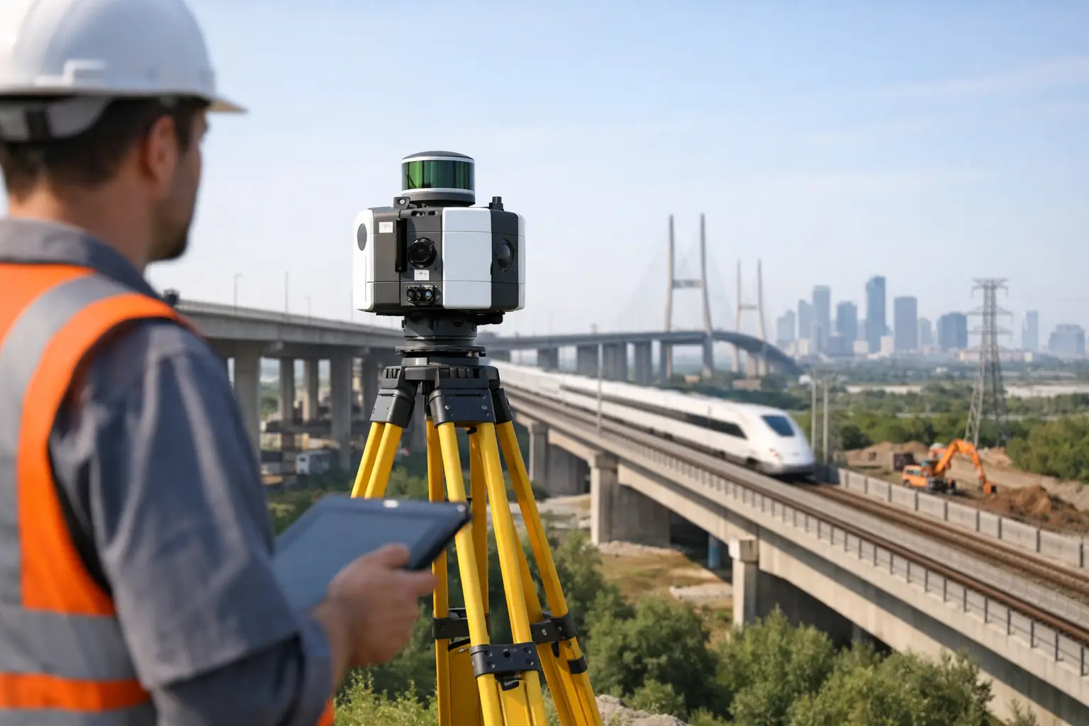
What a lidar survey for infrastructure actually delivers
LiDAR measures distance by recording the return time of laser pulses reflected from the ground, structures, and vegetation. In infrastructure work, that raw measurement becomes a classified point cloud, digital terrain model, digital surface model, contours, cross sections, feature extraction, and engineering-ready mapping layers. The technical distinction matters because project teams rarely need unprocessed sensor files. They need traceable surfaces, known accuracies, and interpreted deliverables aligned to design and asset workflows.
The strongest use case is where conventional survey methods struggle with scale, access, or safety. Long transport corridors, utility routes, flood-prone catchments, substations, industrial compounds, and rapidly changing construction zones are all examples. Drone-based LiDAR is especially effective where mobilization speed and operational flexibility determine whether a survey supports the program or delays it.
In the Gulf, those constraints are amplified by heat, dust, remote access, and compressed development timelines. A disciplined aerial workflow reduces dependence on extended ground crews while still producing cross-validated spatial data that engineers and planners can use with confidence.
Where LiDAR outperforms conventional methods
A total station or GNSS crew still has a place in control establishment and local detail verification. The issue is coverage. As project footprints grow, ground survey can become slower, less consistent, and more exposed to access restrictions. Manned aircraft can cover larger areas, but they often introduce higher mobilization cost and less flexibility for repeat surveys.
LiDAR sits in the middle with a strong operational advantage. It captures high-density elevation and structural data at speed, including areas where vegetation, embankments, or uneven ground make line-of-sight surveying inefficient. For roads, rail, pipelines, transmission lines, ports, industrial plants, dams, and urban utility corridors, this combination of density and speed can materially shorten the time between fieldwork and engineering use.
That does not mean LiDAR is always the cheapest method on paper. If a site is very small, fully accessible, and only requires a limited set of spot elevations, a conventional crew may be sufficient. The benefit of LiDAR becomes clearer when the project requires repeatability, broad area coverage, volumetric understanding, or a permanent digital record of conditions at a given date.
Why infrastructure teams use LiDAR early, not just during construction
The common mistake is to treat LiDAR as a construction support tool only. In reality, the highest return often appears much earlier. Route selection, grading studies, drainage assessment, utility conflict screening, and access planning all improve when the terrain model is based on current, dense, and classified data rather than legacy mapping.
Early-stage survey quality affects capital efficiency. If drainage behavior is misunderstood, cut-and-fill assumptions are wrong, or utility crossings are under-characterized, those errors move downstream into design revisions, change orders, and schedule disruption. A well-executed LiDAR program reduces those risks because it provides a common spatial baseline across planning, design, and execution teams.
Later in the project cycle, the same survey framework supports progress tracking, as-built verification, slope and embankment monitoring, right-of-way management, and asset inspection planning. That continuity matters. Infrastructure programs do not fail because one map is missing. They fail because data handoffs are inconsistent, dated, or not auditable.
The acquisition standard matters as much as the platform
Not all LiDAR surveys are equivalent. The reliability of the final dataset depends on flight planning, sensor calibration, ground control strategy, inertial measurement quality, GNSS performance, overlap settings, point density targets, and post-processing discipline. In infrastructure settings, these variables should be defined by engineering use case, not by generic flight templates.
For example, a corridor survey for preliminary route design may prioritize efficient coverage and terrain penetration across a broad area. A plant expansion survey may require much tighter control on structural definition, occlusion management, and feature extraction around congested assets. A flood analysis dataset may place greater emphasis on bare-earth accuracy, breakline support, and hydrologically coherent terrain modeling.
This is where specialist contractors separate themselves from commodity operators. A credible provider will specify accuracy classes, control methodology, classification logic, QA/QC checkpoints, and reporting structure before mobilization. The point is not to produce more data. The point is to produce data that aligns with the engineering and commercial decisions at stake.
Key outputs infrastructure teams should expect
A lidar survey for infrastructure should end with usable deliverables, not just a large file transfer. Most project teams need a structured package that includes classified point clouds, digital terrain and surface models, orthomosaic context where relevant, contours, profiles, and CAD or GIS-ready layers. Depending on scope, they may also require extracted utility poles, conductors, road edges, barriers, drainage channels, stockpile volumes, or deformation baselines.
Auditability is central. Metadata, coordinate reference information, calibration records, control reports, accuracy checks, and processing logs should be available and internally consistent. For enterprise buyers and government agencies, that traceability is often as important as resolution. If the dataset cannot be defended, it becomes difficult to use in claims analysis, regulatory review, or contractor coordination.
Multi-sensor workflows improve infrastructure intelligence
LiDAR is powerful, but infrastructure decisions often benefit from sensor fusion. Photogrammetry adds visual context for asset interpretation and stakeholder communication. Thermal or hyperspectral sensing can support condition assessment in selected utility and environmental cases. Magnetometry or utility detection methods may add subsurface context where buried services or geological constraints affect alignment and design.
A multi-sensor approach is not always necessary. It adds processing complexity and should be justified by the decision requirement. But on high-value projects, integrated acquisition can reduce repeat mobilizations and create a more complete geospatial model of terrain, structures, and hidden constraints. That is particularly useful in fast-moving programs where field access windows are short and rework is expensive.
Common procurement mistakes
Infrastructure buyers sometimes procure LiDAR on point density alone. That is an incomplete metric. Density matters, but classification quality, control integrity, penetration performance, and deliverable design often matter more. A dense but poorly calibrated point cloud can still create engineering risk.
Another mistake is to separate acquisition from interpretation too aggressively. Raw data processing without sector-specific reporting tends to push technical burden back onto the client team. For owners and EPC firms managing multiple work packages, that defeats the purpose of outsourcing specialist survey work.
A better procurement approach defines the intended use of the data, required accuracy, reporting standards, coordinate system, asset classes to be extracted, and acceptance criteria. It also asks how the provider manages reflight decisions, QA/QC exceptions, and version control. Those details are not administrative. They determine whether the final dataset accelerates work or creates another layer of technical review.
Why drone deployment changes the economics
Drone-based survey operations are not simply a smaller version of manned aviation. They shift the economics of mobilization, repetition, and site access. For infrastructure projects that need staged surveys across planning, earthworks, structural buildout, and operations, that flexibility has direct commercial value.
Repeat capture becomes practical. Hazard exposure for field teams can be reduced. Remote or harsh environments can be surveyed without the same logistical burden. Air Solutions operates in precisely that space, where desert conditions, industrial access constraints, and compressed schedules demand a platform that is fast to mobilize and disciplined in execution.
The critical point is that drones are only an advantage when paired with controlled methodology. Without calibration discipline, airspace compliance, and processing rigor, the platform benefit is wasted. Enterprise clients are not buying flight hours. They are buying reliable spatial intelligence with a clear chain of custody.
What good looks like in project delivery
A strong LiDAR program begins with a technical scoping conversation, not a price sheet. The provider should ask what decisions the survey must support, what tolerances are acceptable, how the data will be consumed, and where site-specific risks may affect capture quality. From there, acquisition parameters and deliverables can be engineered around the project rather than forced into a generic package.
That approach is especially relevant for national infrastructure, utilities, water assets, and industrial expansion in Saudi Arabia and the wider Gulf. Projects move quickly, interfaces are complex, and the cost of bad spatial assumptions is high. Decision-makers need terrain and asset intelligence that is calibrated, traceable, cross-validated, and ready for engineering use.
The practical test is simple. A good survey does not just map what is there. It reduces uncertainty enough for the next decision to be made faster and with less risk. That is where LiDAR earns its place - not as a visualization tool, but as a disciplined source of infrastructure intelligence.