A greenfield target can lose months before a drill program starts, not because geology is unclear, but because data acquisition is slow, access is constrained, or field exposure is too high. That is where how drone magnetics reduce risk becomes a commercial and operational question, not just a technical one. For mining, water, energy, and infrastructure programs, the value of drone magnetics is not limited to anomaly detection. It lies in reducing uncertainty across safety, schedule, cost control, and decision quality.
Why risk reduction matters more than raw survey coverage
In high-value projects, risk rarely sits in one place. It accumulates across mobilization delays, difficult terrain, permit constraints, inconsistent ground data, and gaps between acquisition and interpretation. Traditional magnetic surveys can still be appropriate, but they often force trade-offs. Ground crews may achieve detailed local coverage, yet they do so with slower line production and more field exposure. Manned aircraft can cover large areas efficiently, but they may not be economical or practical for smaller blocks, low-altitude targets, or rapidly changing project scopes.
Drone magnetics changes that equation by giving project teams a calibrated, low-altitude survey method that can be deployed quickly and controlled tightly. For enterprise buyers, that means fewer assumptions built into early-stage planning and fewer blind spots carried into engineering, drilling, trenching, or corridor design.
How drone magnetics reduce risk in the field
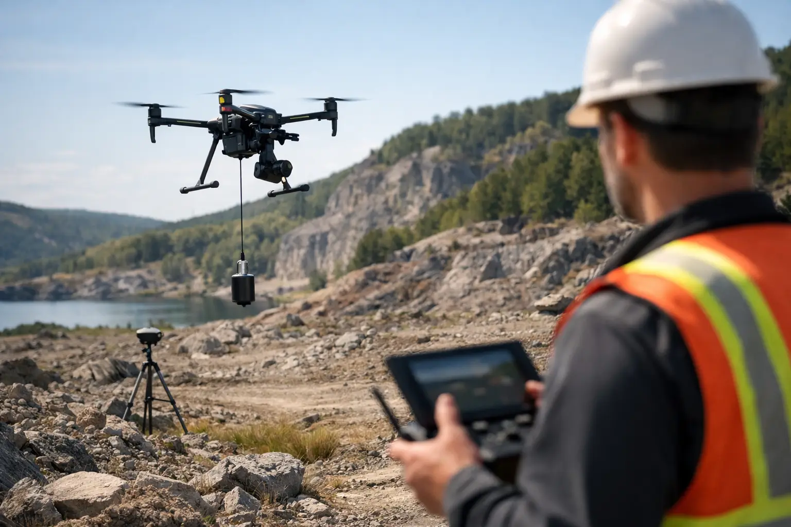
The first and most visible advantage is reduced personnel exposure. When magnetic data can be collected from an unmanned platform, fewer people need to work on foot across unstable ground, remote wadis, steep escarpments, active industrial zones, or heat-stressed desert environments. That matters in Saudi and Gulf operating conditions, where temperature, remoteness, and logistics can quickly turn routine fieldwork into a safety management problem.
A drone-based magnetic survey also reduces vehicle dependence in areas with poor access. Ground teams often need tracks, clearing, or repeated traverses to achieve acceptable spacing. Each additional movement introduces safety exposure, equipment wear, and schedule volatility. By contrast, a properly designed drone survey can collect repeatable lines over the same area without imposing the same access burden on crews or support vehicles.
There is also a more technical safety dimension. In brownfield environments, utilities, pipelines, facilities, and restricted zones complicate data capture. Drone platforms can be planned around exclusion areas with tighter positional control and clearer operational discipline than ad hoc ground traverses. The result is a safer acquisition envelope and better documentation of what was flown, when, and under what conditions.
Better access means lower interpretation risk
Risk is not only about incident prevention. It is also about whether the final dataset is strong enough to support investment and engineering decisions. In many projects, the highest downstream cost comes from acting on incomplete or poorly resolved subsurface information.
Drone magnetics improves access to areas that are difficult to survey consistently from the ground. That includes rocky outcrops, dune fields, flood-prone channels, fenced corridors, and zones where vegetation or surface obstacles disrupt line continuity. When these gaps are left unsurveyed or stitched together from inconsistent field methods, interpreters inherit uncertainty that can distort structural mapping, target ranking, or utility tracing.
Low-altitude drone acquisition reduces the sensor-to-target distance, which typically improves anomaly definition compared with higher-altitude airborne methods. That sharper signal can materially improve the delineation of faults, dikes, buried ferrous objects, lithologic contacts, and other magnetic contrasts. Better anomaly definition does not eliminate interpretation ambiguity, but it narrows it. For exploration managers and infrastructure planners, that is a direct reduction in decision risk.
Schedule risk drops when mobilization is faster
Large projects are often delayed by small operational bottlenecks. Aircraft availability, permitting windows, crew coordination, site access preparation, and weather exposure all affect survey timelines. Drone magnetic systems are not immune to these constraints, but they generally compress them.
A drone platform can be mobilized faster than a manned airborne campaign and with less field infrastructure than an equivalent ground program. That matters for pilot surveys, rapid target screening, route investigations, and phased development programs where decision-makers need technical evidence quickly. Faster deployment allows project owners to test assumptions earlier, reject weak targets sooner, and prioritize follow-on work with more confidence.
This speed advantage becomes more significant when survey outputs are integrated into a traceable processing and QA/QC workflow. Fast collection without disciplined processing simply moves risk downstream. Fast collection paired with calibrated acquisition, line leveling, positional verification, and interpretation-ready deliverables shortens the time between field activity and boardroom decisions.
How drone magnetics reduce risk for data quality
The strongest argument for drone magnetics is not that it is newer. It is that, when executed correctly, it can deliver highly controlled data at the scale many industrial projects actually need. This is central to how drone magnetics reduce risk in commercially sensitive programs.
Data quality risk usually enters through altitude inconsistency, magnetic noise, poor navigation, inadequate base station control, or weak processing discipline. A professional drone magnetic survey addresses these issues with calibrated sensors, validated flight planning, environmental controls, and auditable correction workflows. Those controls matter because enterprise buyers are not purchasing flight hours. They are purchasing defensible geospatial intelligence.
This distinction is critical. A magnetic map that looks visually convincing but lacks traceability is a procurement risk. It can be challenged during technical review, fail to align with drilling outcomes, or require costly rework. In contrast, a survey delivered with documented methodology, cross-validation, and sector-specific interpretation has a very different value profile. It can support reserve evaluation, groundwater targeting, route selection, utility risk screening, or early engineering with a much stronger evidentiary basis.
The trade-offs decision-makers should understand
Drone magnetics is not a universal replacement for every survey method. Survey design still depends on area size, target depth, topography, airspace constraints, magnetic latitude, required resolution, and the economics of the decision being supported.
For very large regional programs, manned aircraft may still be more efficient on pure area coverage. For ultra-detailed site investigations in congested environments, ground methods may remain valuable for local confirmation. Drone magnetics sits in the high-value middle ground where low-altitude resolution, fast deployment, and reduced field exposure outweigh the limits of endurance and payload.
That is why method selection should be tied to risk class, not habit. If the main issue is personnel exposure in harsh terrain, drones can materially improve the operating profile. If the issue is rapid, decision-grade screening over a moderate block, drones are often highly efficient. If the issue is continental-scale reconnaissance, another platform may be more appropriate. The right question is not whether drones are better in the abstract. It is whether they reduce the most expensive risks in the specific project.
Sector implications for mining, water, and infrastructure
In mineral exploration, drone magnetics helps reduce the risk of drilling the wrong structural model. Sharper magnetic detail can improve the understanding of fault architecture, intrusive boundaries, and target continuity before expensive ground campaigns or drilling begin.
In groundwater exploration, magnetic data can contribute to basement mapping, structural interpretation, and the identification of features relevant to hydrogeological models when integrated with other geophysical and remote sensing datasets. The risk reduction comes from narrowing the search space before field development capital is committed.
In infrastructure and utility corridors, drone magnetics can support route intelligence where buried ferrous features, access limitations, or brownfield conditions complicate conventional survey methods. The commercial benefit is straightforward: fewer surprises during design and construction.
Providers such as Air Solutions position drone magnetics within a broader multi-sensor framework for exactly this reason. Magnetic data becomes more valuable when it is fused with LiDAR, photogrammetry, electromagnetic methods, or sector-specific interpretation workflows rather than treated as a standalone map product.
What buyers should ask before commissioning a survey
Not all drone magnetic surveys reduce risk to the same degree. Buyers should evaluate whether the provider can document calibration procedures, flight controls, positional accuracy, magnetic compensation methods where applicable, and processing lineage from acquisition through final interpretation. They should also ask how the survey design matches the business decision at stake.
That last point matters. A survey built for broad reconnaissance should not be sold as if it were engineered for drill targeting. A corridor screening dataset should not be presented as a substitute for full construction-stage utility characterization. Risk is reduced when scope, method, and deliverable are aligned from the start.
The most useful drone magnetic programs do more than collect data. They compress uncertainty in a way that is measurable, traceable, and relevant to the next capital decision. That is the standard serious operators should expect, especially where project timelines are narrow and the cost of being wrong is high.
As subsurface decisions become faster and more capital-sensitive, the real advantage of drone magnetics is clarity under operational pressure - safer acquisition, tighter control, and data that stands up when the project moves from planning to commitment.