When a project team asks whether aeromagnetic versus ground magnetics is the better choice, the real issue is not which method is superior in the abstract. It is which method will produce decision-grade magnetic data, at the required spatial resolution, within the project’s access, safety, budget, and schedule constraints. For mining, groundwater, infrastructure, and utility programs, that decision affects not only data quality but also mobilization speed, permitting exposure, and the defensibility of downstream interpretations.
Magnetics is often treated as a straightforward geophysical layer. In practice, survey design controls whether the output becomes a useful geological product or just another raster in a GIS. The platform, sensor height, line spacing, navigation quality, magnetic compensation, diurnal correction strategy, and QA/QC discipline all influence what can be resolved and how confidently anomalies can be tied to structure, lithology, alteration, buried ferrous objects, or man-made interference.
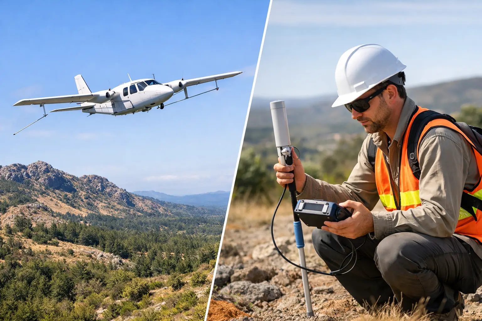
Aeromagnetic versus ground magnetics: the core difference
Aeromagnetic surveys measure variations in the Earth’s magnetic field from an airborne platform, now increasingly using low-altitude UAV systems rather than manned aircraft. Ground magnetic surveys measure the same field from sensors carried by personnel, mounted on backpacks, towed on carts, or deployed on vehicles. The physics is shared. The survey geometry is not.
That geometry matters immediately. Aeromagnetic data is acquired above the surface, usually at a consistent draped or level flight height, across broad areas with repeatable line spacing and high production rates. Ground magnetics places the sensor much closer to the source, which improves sensitivity to shallow and compact targets but reduces area coverage and introduces terrain, vegetation, and access limitations.
For a technical buyer, the first distinction is therefore operational rather than theoretical. Aeromagnetic is typically the faster regional or project-scale screening tool. Ground magnetics is typically the higher-detail near-surface method for areas where access is manageable and finer anomaly definition is required.
Resolution, depth response, and what each method actually sees
The strongest argument for ground magnetics is proximity to the target. Magnetic field strength decays rapidly with distance, so a sensor operating near the surface is better positioned to detect subtle, shallow, and short-wavelength anomalies. If the objective is mapping near-surface contacts, trench extensions, utility corridors, UXO-related ferrous disturbance, or discrete cultural features, ground systems often provide sharper anomaly character.
Aeromagnetic surveys trade some of that short-wavelength sensitivity for consistent, scalable coverage. With modern low-altitude UAV deployment, the gap is narrower than many legacy assumptions suggest. Flying lower and slower than conventional manned aircraft allows high-resolution aeromagnetic acquisition over complex terrain and remote zones, while maintaining survey efficiency across large footprints.
Depth response is often misunderstood. Neither aeromagnetic nor ground magnetics directly measures depth in the way a drilling program confirms depth. Both infer source geometry through anomaly amplitude, wavelength, gradients, and modeling. Ground data can improve shallow target discrimination because the sensor is closer to the source. Aeromagnetic data can still detect deeper structural trends and lithologic domains effectively, especially when the objective is regional structural framework rather than pinpointing a shallow object.
This is why target definition matters. If the goal is basin architecture, fault corridors, dike swarms, basement trends, or alteration-related structural controls across tens to hundreds of square kilometers, aeromagnetic is often the better first-pass method. If the goal is refining a compact anomaly before trenching or drilling, ground magnetics may be the better second-pass method.
Coverage, access, and schedule pressure
In enterprise projects, schedule risk is often more expensive than survey cost. Ground crews move at ground speed. They are constrained by rough terrain, heat load, slope, vegetation, security protocols, property boundaries, and surface obstruction. In desert and industrial environments, those constraints can be decisive.
Aeromagnetic systems have a different operational profile. They can cover large areas quickly, maintain line discipline, and access terrain that would be slow, hazardous, or impractical for foot surveys. In Saudi Arabia and the wider Gulf, where project sites may combine heat, remoteness, restricted zones, and compressed execution windows, airborne deployment can materially reduce field exposure while accelerating acquisition.
That does not make ground work obsolete. It means the two methods serve different operational roles. Ground magnetics is still highly effective where the site is accessible, the target is shallow, and the anomaly needs close-interval sampling. But if field access itself threatens schedule certainty, aeromagnetic gains a strong commercial advantage.
Cost is not just a day rate question
Procurement teams often compare airborne and ground surveys through direct acquisition cost per square mile or per line mile. That is a useful starting point, but it is incomplete. The more relevant metric is cost per validated decision.
Ground magnetics can appear less expensive for a small, simple site. On larger footprints, that equation changes quickly. Personnel time, safety management, vehicle support, access delays, line cutting, and resurvey requirements can push total cost upward. Aeromagnetic surveys may carry a higher mobilization threshold, but they often become more cost-efficient as area increases, especially where access is poor or the program demands rapid screening.
There is also a hidden cost in under-specification. A ground survey that is too limited in extent may miss the structural context needed for interpretation. An airborne survey flown too high or too wide in line spacing may fail to resolve the target class. Method selection should therefore be tied to the geological question and the required confidence level, not only the cheapest acquisition option.
Data quality, noise, and QA/QC discipline
Both methods are vulnerable to noise, but the noise sources differ. Ground magnetics is affected by operator movement, heading effects, nearby vehicles, fences, pipelines, and metallic clutter. Terrain can complicate sensor height consistency, which directly influences anomaly amplitude. In industrial corridors, cultural interference can overwhelm subtle geological signal.
Aeromagnetic surveys introduce their own control requirements. Platform magnetic noise, sensor mounting geometry, compensation routines, navigation quality, line leveling, tie-line control, and diurnal correction all need disciplined management. UAV-based systems, when properly calibrated and operated under traceable SOPs, can deliver highly repeatable results, but only if acquisition and processing are engineered as a single quality-controlled workflow.
This is where mature QA/QC matters more than the platform label. Buyers should expect documented calibration, base station integration where required, line-to-line consistency checks, altitude control verification, processing logs, and interpretable deliverables rather than uncontextualized grids. A fully auditable dataset is more valuable than nominally high-resolution data with weak process control.
When aeromagnetic is the stronger choice
Aeromagnetic is generally the stronger option when the survey area is large, access is constrained, and the objective is to establish structural or lithologic context efficiently. It is particularly effective in early-stage exploration, regional screening, infrastructure corridor planning, and remote groundwater investigations where rapid spatial continuity matters.
It also performs well when project teams need multi-sensor integration. Magnetic data becomes more useful when cross-validated against LiDAR, photogrammetry, electromagnetic data, radiometrics, or mapped surface geology. Airborne platforms are well suited to that integrated approach because they can acquire consistent geospatial layers at project scale. For contractors such as Air Solutions, the value is not just flying magnetics. It is delivering interpreted, cross-validated geoscience products that reduce uncertainty across the broader site model.
When ground magnetics remains the better method
Ground magnetics is often the better choice when the target is shallow, compact, and already constrained to a small area. It is also appropriate where clients need very tight station spacing, close control over obstacle avoidance, or localized follow-up over anomalies identified by airborne data.
In brownfield sites, utility investigations, archaeological sensitivity zones, and drill-target refinement, ground methods can provide the anomaly sharpness needed to support the next field decision. If access is straightforward and the survey footprint is limited, ground acquisition may be the most efficient path to a high-detail result.
The mistake is assuming that better near-surface resolution automatically means better project value. If the site needs broad context first, a very detailed ground grid can answer the wrong question with great precision.
The best answer is often staged, not either-or
For many programs, aeromagnetic versus ground magnetics is a false binary. The strongest survey design is often sequential. Airborne magnetics defines the regional framework, identifies anomaly clusters, and compresses the search area. Ground magnetics then follows over selected zones to tighten target geometry, support modeling, and guide trenching, drilling, or engineering decisions.
That staged approach is especially effective when capital discipline matters. It avoids overspending on detailed ground work across low-priority ground while still preserving the option for close-interval follow-up where the data justifies it. It also improves interpretive confidence because broad-scale structure and local anomaly character are evaluated together rather than in isolation.
A technically sound procurement decision starts with four questions: What is the target class, what area must be covered, what level of resolution is truly required, and what field constraints could compromise execution? Once those are answered honestly, the method choice becomes clearer.
The right magnetic survey is the one that fits the geology, the terrain, and the decision that follows next. If the data cannot stand up to technical review, board-level scrutiny, or field validation, the platform choice was never the real problem.