When a corridor survey slips its schedule because crews are still chasing ground shots across rough terrain, the lidar vs total station question stops being theoretical. It becomes a procurement, risk, and delivery decision. For mining, infrastructure, utilities, and water projects, the right instrument is the one that produces decision-grade data at the required tolerance, within the actual site constraints, and with a traceable path from acquisition to final deliverable.
LiDAR vs total station: the real decision criteria
Too many comparisons reduce this to a single variable, usually accuracy. That is not how serious projects are executed. Accuracy matters, but so do coverage rate, line-of-sight limitations, crew exposure, mobilization speed, terrain accessibility, rework risk, and how well the resulting dataset supports downstream engineering or asset workflows.
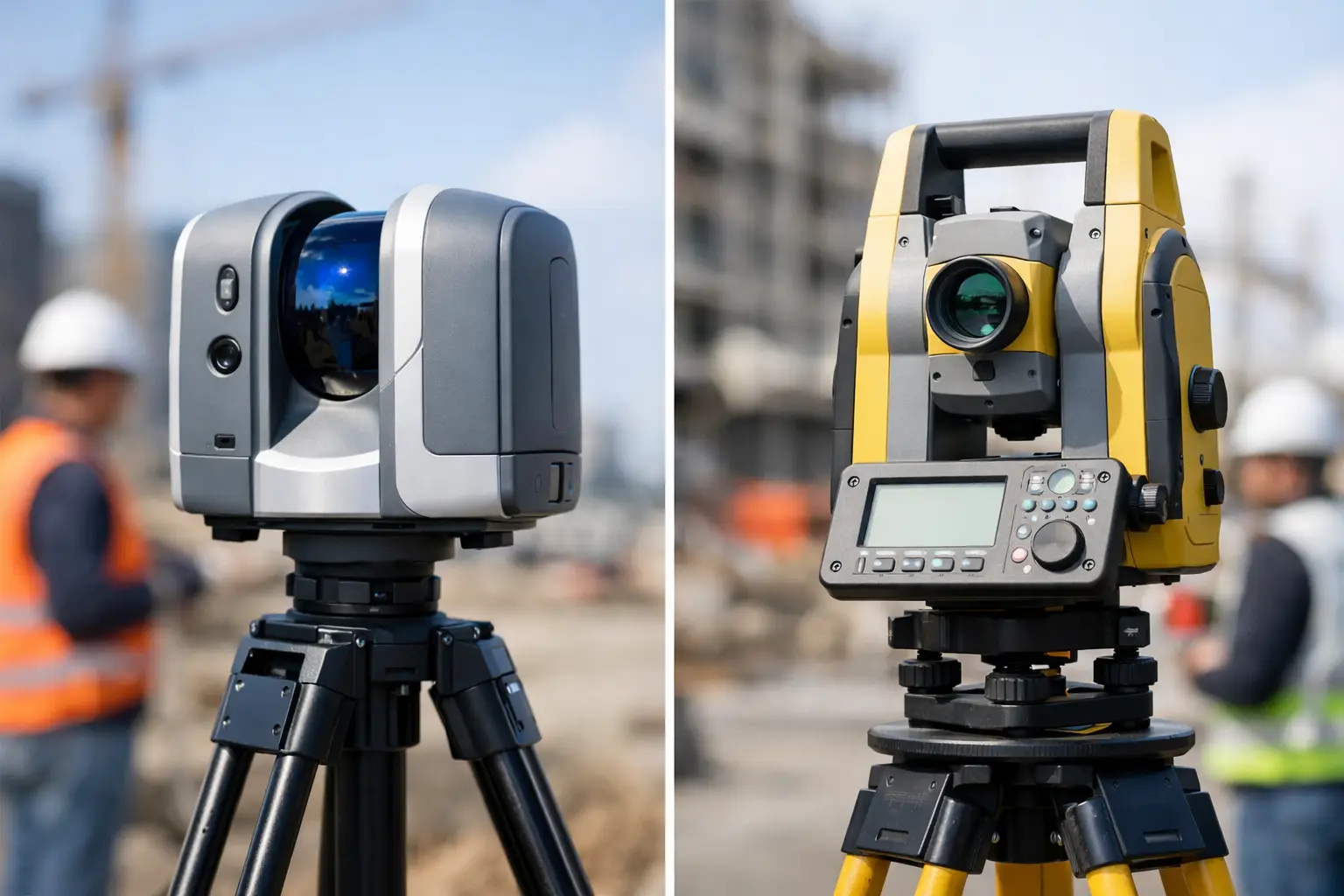
A total station is a point-measurement instrument. It is excellent when a project needs deliberate, controlled observations on specific features, with clear survey control and established field procedures. It remains a core tool for setting out, deformation monitoring, structural layout, and any task where a crew needs exact coordinates on selected points rather than full-surface capture.
LiDAR is a dense spatial sampling method. Whether deployed from drone, vehicle, or tripod, it captures a high-volume point cloud across large areas and complex surfaces far faster than conventional point-by-point collection. That changes the value proposition. Instead of deciding in the field which points might matter later, teams can collect broad, auditable spatial coverage and classify or extract features during processing.
The operational distinction is simple. Total stations measure chosen points with high control. LiDAR captures environments at scale.
Where total stations still lead
Total stations remain highly effective in controlled survey environments. If a contractor needs building corners, pavement edges, utility tie-ins, or stakeout coordinates with direct field verification, the instrument is efficient and defensible. On sites with unobstructed visibility, short ranges, and a finite number of required observations, the workflow is straightforward and cost-effective.
This matters in industrial settings where tolerances are tight and the survey objective is narrow. Structural steel alignment, plant expansion layout, and monitoring of specific targets are not density problems. They are precision-on-known-features problems. In those cases, a total station often delivers exactly what the engineer asked for, with no excess data burden.
There is also a process advantage. Many engineering and construction teams already have established QA/QC procedures around traverses, backsights, prism shots, and control checks. The chain of custody is familiar. For regulated projects or contract frameworks built around conventional survey specifications, that familiarity can reduce approval friction.
But those strengths depend on access and visibility. Once terrain gets broken, surfaces become irregular, or site hazards limit where crews can stand, total station productivity drops quickly.
Where LiDAR changes project economics
LiDAR earns its position when the site is large, inaccessible, vertically complex, or time-sensitive. A drone-based LiDAR survey can acquire terrain, stockpiles, corridors, embankments, wadis, pits, and utility routes in a fraction of the field time required for dense ground pickup. That speed is not just a convenience. It affects project cost, HSE exposure, and schedule reliability.
For enterprise buyers, the bigger advantage is often completeness. A total station dataset reflects what the field crew selected. A LiDAR dataset reflects what the sensor observed across the surveyed extent. That distinction matters when scope shifts after acquisition. If drainage analysis, volumetrics, slope stability review, or as-built verification become necessary later, a dense point cloud often preserves options that sparse point collection does not.
In desert and infrastructure environments, this is especially relevant. Long linear assets, remote mining blocks, and uneven ground can turn conventional survey into a slow campaign of repeated setups and target occupation. Drone LiDAR compresses that field effort while reducing the need for personnel to physically traverse unstable or exposed areas.
That does not mean LiDAR removes survey discipline. It demands calibrated sensors, surveyed control, boresight validation, strip alignment checks, classification protocols, and documented accuracy reporting. Without that framework, point cloud density can create false confidence. With it, LiDAR becomes a high-output, fully auditable acquisition method suitable for engineering and planning decisions.
Accuracy is not one number
Any honest lidar vs total station discussion needs to separate relative precision from project-level accuracy. A total station can produce extremely precise observations on discrete points. That is one reason it remains indispensable. LiDAR, by contrast, distributes observations over millions of points, each influenced by GNSS quality, IMU performance, scan geometry, platform stability, control design, and post-processing rigor.
So the real question is not which tool is more accurate in the abstract. It is whether the method can meet the required accuracy specification for the intended use. If the requirement is millimeter-sensitive setting out, a total station is usually the correct primary instrument. If the requirement is topographic mapping, surface modeling, corridor analysis, volumetrics, or broad as-built intelligence across a large site, LiDAR may achieve the needed tolerance far more efficiently.
Sophisticated projects often use both. Control networks and validation points may be established with total station or GNSS, while LiDAR handles full-area capture. This blended workflow is often the most defensible approach because it combines targeted control with scalable acquisition.
The cost question is usually misread
Some buyers compare unit cost per survey day and assume the lower field rate wins. That is incomplete. The meaningful comparison includes total delivery cost: mobilization, field duration, traffic or site access controls, standby exposure, safety management, revisit risk, processing time, and the downstream value of the dataset.
A total station can be less expensive for a compact scope with limited shot counts. It can become more expensive when the site area expands, when repeated setups consume labor, or when a sparse dataset leads to missed features and return visits. LiDAR can carry a higher technical setup and processing burden, but on the right project it reduces total program cost by shortening acquisition windows and delivering broader utility from a single campaign.
For large asset owners, the best metric is not cheapest capture. It is lowest cost for decision-grade coverage with acceptable risk.
Field constraints often decide the winner
Procurement teams sometimes treat sensor selection as a purely technical exercise. In practice, site conditions often settle the matter first.
If the site has clear sightlines, stable footing, and a tightly defined feature list, total station workflows remain highly competitive. If the site includes steep cut faces, active haul roads, flood channels, berms, inaccessible utility corridors, or operational restrictions around personnel movement, LiDAR has a significant operational advantage.
The same logic applies to schedule pressure. On fast-moving construction or mining programs, a slower survey method can create bottlenecks for design updates, progress reconciliation, or contractor claims support. High-density acquisition delivered quickly is not just about efficiency. It supports better governance because stakeholders are working from current spatial intelligence rather than partial or outdated field data.
This is where disciplined drone operations matter. A capable provider does more than fly a sensor. It designs the control strategy, validates accuracy, documents QA/QC, and converts raw point clouds into terrain models, contours, classified surfaces, or interpreted geospatial outputs that engineers and planners can use immediately.
Choosing the right method for your project
If your deliverable depends on selected points, direct setout, or structural control, a total station is likely central to the workflow. If your deliverable depends on terrain continuity, volumetric certainty, corridor context, or area-wide feature extraction, LiDAR usually offers the stronger business case.
For many high-value projects, the most effective answer is not lidar vs total station as an either-or choice. It is deciding where each tool sits in the measurement architecture. Total station establishes and verifies critical control. LiDAR scales capture across the full environment. Used together, they produce data that is faster to acquire, easier to validate, and more useful across engineering, planning, and reporting functions.
For organizations operating in mining, utilities, infrastructure, and water resource development, the decision should be framed around deliverable quality, field risk, and schedule certainty - not legacy habit. Air Solutions approaches that decision as an execution problem: match the sensing method to the site, calibrate the workflow to the required tolerance, and deliver outputs that remain traceable under technical and commercial scrutiny.
The most expensive survey method is usually the one that answers yesterday's question and leaves tomorrow's team back in the field.