استكشاف
المياه الجوفية.
تدفقات عمل متكاملة كهرومغناطيسية ومغناطيسية وجاذبية جوية لتحديد حدود الخزانات وتوصيف الهياكل الهيدروجيولوجية وتحديد أهداف الحفر المثلى عبر التضاريس القاحلة للمملكة. تقليل مستهدف لمخاطر الآبار الجافة.
- الطرق
- كهرومغناطيسي جوي + مغناطيسي + جاذبية
- عمق التحقيق
- 0-400 م
- الدقة
- حساسية 1-5 أوم·م
- التغطية
- ~50 كم²/يوم
- المخرج
- تقرير توصية مواقع الحفر
استهداف المياه تحت السطحية على نطاق واسع.
هيدروجيولوجيا المملكة العربية السعودية تهيمن عليها خزانات الحجر الرملي العميقة وأنظمة طمي محكومة هيكلياً. تحديد المناطق المنتجة على مقياس الآبار يتطلب أكثر من الاستشعار عن بعد بالأقمار الصناعية أو الجيولوجيا السطحية — يتطلب قياساً مباشراً للتوصيلية تحت السطحية.
أنظمة EM الجوية لدينا تصور التوصيلية حتى عمق 400 م بسرعة المسح، حلاً للتباين بين خزانات المياه العذبة (مقاومة عالية) والمناطق المالحة (توصيلية عالية). تضيف بيانات المغناطيسية والجاذبية السياق الهيكلي — شبكات الصدوع التي تتحكم في تغذية وترابط الخزانات.
المخرج ليس خريطة — بل قائمة مرتبة بتوصيات مواقع الحفر، كل منها مع دليل جيوفيزيائي داعم، جودة المياه المتوقعة، ونطاق الثقة على الأفق المنتج.
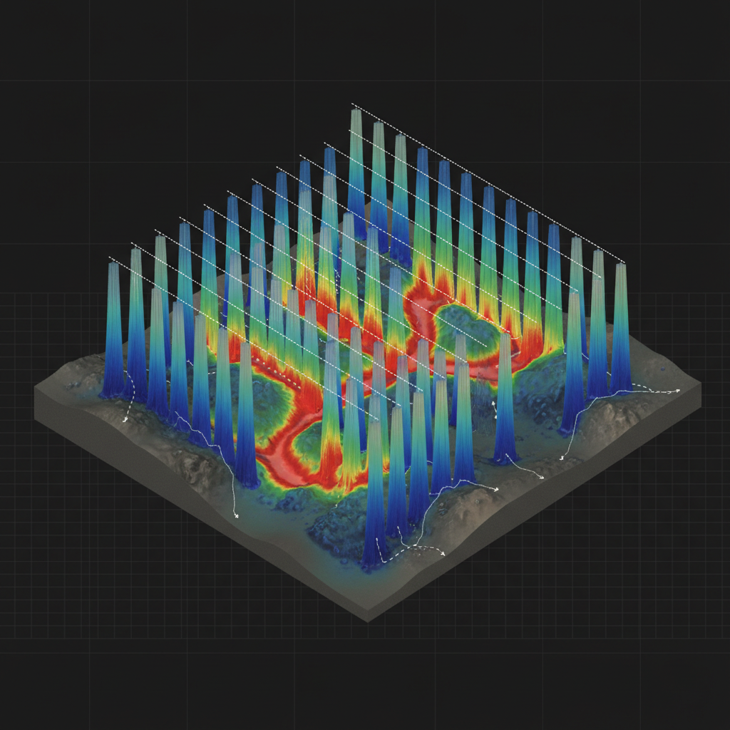
نموذج توصيلية ثلاثي الأبعاد
ستائر توصيلية مخيطة تحت خطوط الطيران، تعزل خزاناً منتجاً من المياه العذبة بين قاعدة مقاومة وغطاء موصل.
ممر تغذية هيكلي
انعكاس مقيد جانبياً 1D ← بناء نموذج كتلي 3D ← تفسير مُصحح بالصدوع ← ترتيب أهداف الحفر ← توقع كيمياء المياه (وكيل TDS).
من خريطة التوصيلية إلى بئر منتج.
إحاطة هيدروجيولوجية
مراجعة الآبار الموجودة، الصخور، البنية الإقليمية. تحديد العمق المستهدف ونوع المياه المتوقع وقيود مواقع الحفر مع هيدروجيولوجي العميل.
اكتساب كهرومغناطيسي جوي
EM في المجال الزمني أو الترددي يطير فوق المنطقة المستهدفة مع بيانات مغناطيسية وتدرج جاذبية مُلتقطة معاً.
الانعكاس والنمذجة
1D LCI متبوع بانعكاس كتلي 3D. نموذج التوصيلية مدمج مع الخطوط المغناطيسية لتحديد الخزانات المحكومة بالصدوع.
تقرير مواقع الحفر
أهداف حفر مرتبة مع توقع العمق إلى المياه وسمك الخزان ووكيل الملوحة والمبرر الهيكلي. تُسلَّم لفريق حفر العميل.
ما تتلقاه.
نموذج توصيلية ثلاثي الأبعاد
حجم توصيلية كتلي 3D حتى عمق التحقيق. Voxel + GeoTIFF.
مقاطع توصيلية-عمق
مقاطع عمودية 2D على طول خطوط المسح + مقاطع عرضية مفسرة.
خريطة سمك الخزان
سمك أفق منتج مفسر مع نطاقات الثقة.
خريطة وكيل الملوحة
تقدير TDS مشتق من التوصيلية مع المعايرة مقابل الآبار الموجودة.
أهداف حفر مرتبة
مواقع مرتبة بالأولوية مع الإحداثيات والعمق المتوقع والمبرر.
تقرير هيدروجيولوجي
تقرير PDF يربط الجيوفيزياء بالهيدروجيولوجيا الإقليمية + سلسلة الحيازة.
أين تُنشر هذه الخدمة.
استهدف خزانك الجوفي.
شارك منطقة اهتمامك والعمق المستهدف وبيانات الآبار الموجودة. نرد بتصميم مسح وإطار أهداف الحفر وجدول زمني خلال 48 ساعة.